Interactive maps can turn geography from memorization into hands-on discovery. The best picks help kids build confidence with countries, continents, flags, capitals, and directional skills through games, sound, and visual cues.
In this roundup, we focused on interactive world maps for kids that are engaging, age-appropriate, and useful for home learning, classrooms, and travel-inspired play.
Best 10 Interactive World Maps for Kids Picks for 2026
Talking Wall Map
BEST LEARNING i-Poster My World

- Touches 92 countries for spoken names and facts
- Includes 1,000+ facts and 10 quiz modes
- Batteries included; wall or floor use
Best For: Kids ages 5 to 12 who want a hands-on talking geography poster
Screen Globe
LeapFrog Magic Adventures Globe
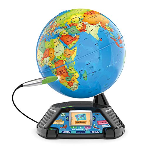
- 2.8-inch screen shows videos and animations
- Thousands of facts plus 3 interactive games
- Stylus and stand create guided play
Best For: Kids 5+ who like a globe with videos and quiz games
Bilingual Talking Poster

- English and Spanish learning support
- 3,500 facts across 195 countries
- Recording feature adds creative play
Best For: Kids ages 3 to 12 learning bilingual geography with a talking poster
Felt Floor Map
Taika World Map Felt Board Set

- Felt pieces include continents, oceans, landmarks, and animals
- No batteries required for quiet screen-free play
- Works as a learning tool and room decor
Best For: Kids ages 4+ who prefer tactile, screen-free geography activities
Reusable Sticker Geography Game
Imagimake Mapology World Map Chart

- 100+ reusable stickers for repeated play
- Five ways to learn geography through games
- Supports memory, focus, and spatial skills
Best For: Kids ages 5+ who enjoy hands-on map activities
Talking Bilingual USA Map
Qiaojoy V2 Interactive USA Map Poster

- Bilingual English and Spanish learning support
- 10 interactive features with 2,000 facts
- Three game modes build memory and matching skills
Best For: Kids ages 3-12 learning U.S. geography with audio
Talking Pen World Map Set
Goldge Interactive World Map with Talking Pen

- Talking pen adds facts, music, and voice prompts
- 3,500 facts across 195 countries
- Includes quizzes plus bonus music and greeting cards
Best For: Kids ages 5-12 who enjoy audio-led geography games
Interactive USA Learning Map

- 51 touch points for states and Washington, D.C.
- 4 learning modes and 300+ quiz questions.
- Batteries included; 5 volume levels.
Best For: kids ages 5 to 12 studying U.S. geography
World Puzzle Map Set
Imagimake Mapology World Map Puzzle

- 75 country pieces, 65 flags, and capital stickers.
- Foam puzzle format supports hands-on learning.
- ASTM-standard EVA foam pieces.
Best For: kids who learn best through puzzles and visual geography
Bilingual Talking Map Set
Qiaojoy Interactive USA & World Map

- USA and world maps in one bilingual set.
- 3,500 world facts and 2,000+ USA facts.
- Includes quiz levels and recording features.
Best For: kids ages 4 to 10 who want bilingual geography play
Talking Wall Map – BEST LEARNING i-Poster My World
For families looking for interactive world maps for kids, this talking poster keeps geography simple and hands-on. Children can touch any of 92 countries to hear names and facts, then move through quiz-and-learn modes that make practice feel like play.
Best For: Kids ages 5 to 12 who learn well with a wall map, spoken facts, and quick quiz games for home or classroom use.
Pros:
- Touches any of 92 countries and speaks them aloud with no app or pen needed.
- Shares more than 1,000 spoken facts, including capitals, flags, landmarks, languages, and population.
- Includes 10 quiz-and-learn modes to build geography, listening, memory, and general knowledge.
- Batteries are included, and the mat can hang on a wall or be used on the floor.
Cons:
- Requires wall or floor space because it is a large poster-style format.
- Made for ages 5 to 12, so it may be less engaging for older children.
This is a strong pick if you want a durable, ready-to-use geography toy that mixes speaking, quizzes, and broad world knowledge in one format.
Screen Globe – LeapFrog Magic Adventures Globe
This is one of the more feature-rich interactive world maps for kids if you want a globe that goes beyond basic geography. It combines a stylus-based quiz experience with a built-in screen that shows videos and animations about cultures, animals, habitats, and more.
Best For: Kids ages 5+ who enjoy facts, games, and video-based learning on a globe with a more immersive format.
Pros:
- Includes a 2.8-inch screen with videos and animations to add visual context.
- Offers thousands of facts plus three interactive games for repeat play.
- Comes with a stylus and stand for a guided, hands-on experience.
- Includes over five hours of BBC videos about cultures, animals, and habitats.
Cons:
- Requires 4 AA batteries, and the included batteries are for demo use only.
- Best suited to children who like screen-based learning, since that is a major part of the experience.
If you want a globe that feels more like an educational game system than a simple map, this one offers a lot of variety and visual engagement.
Bilingual Talking Poster – Qiaojoy Interactive World Map
If you want interactive world maps for kids with bilingual support, this talking poster is built for English and Spanish learning. It adds a recording function and a personalized startup sound, which makes it feel more creative than a standard geography chart.
Best For: Children ages 3 to 12 who are learning English and Spanish and want a map that supports speaking, recording, and exploration.
Pros:
- Bilingual design supports English and Spanish learning.
- Includes 3,500 fun facts about 195 countries.
- Lets kids record stories or songs for a more creative experience.
- Uses an audio pen and manual operation for interactive play.
Cons:
- The stylus is part of the interactive experience, so it is less of a simple touch-only map.
- As a large poster, it needs wall space or a clear area for display.
This is a smart choice for families who want a deeper facts-based map with bilingual learning and a little extra personalization.
Felt Floor Map – Taika World Map Felt Board Set
For a softer, more tactile option in interactive world maps for kids, this felt board set turns geography into hands-on play. Children place continents, oceans, landmarks, and animal icons onto the map, making it a good fit for preschool-style learning and family teaching.
Best For: Kids ages 4+ who learn best with tactile pieces, visual matching, and simple world geography play.
Pros:
- Includes 17 animal icons, 14 famous places, 7 continents, and 5 oceans.
- Made from non-toxic felt with reusable self-adhesive Velcro dots.
- No batteries or electronics required, so it is simple and quiet to use.
- Works as both a learning tool and a room decoration.
Cons:
- Manual felt-piece play offers less audio feedback than talking map toys.
- Best suited to younger children and guided learning rather than advanced geography study.
This set is a solid pick if you want a screen-free map that emphasizes tactile learning, memory building, and hands-on family interaction.
Reusable Sticker Geography Game – Imagimake Mapology World Map Chart
If you want interactive world maps for kids that feel more like play than a lesson, this Imagimake chart is a strong pick. Kids place and reposition reusable stickers onto the wall map, then use the included timer, spinners, and instruction book to explore countries, continents, landmarks, animals, and foods in multiple ways.
Best For: Kids ages 5+ who learn best through hands-on geography play at home or in classrooms.
Pros:
- Includes 100+ reusable stickers for repeated map matching and sorting.
- Five play modes add variety with numbers, timer races, spinners, atlas-style play, and compass directions.
- Wall-mounted format works well for homeschool spaces and classroom learning areas.
- Built to support memory, focus, problem-solving, fine motor skills, and spatial understanding.
Cons:
- Requires wall space for the chart setup.
- Uses a manual play format rather than audio or talking features.
- Best suited to guided learning or active play, not passive review.
This is a well-rounded option if you want a reusable, activity-based world map that keeps geography engaging. The mix of stickers and game-style challenges makes it especially useful for kids who need movement and variety to stay interested.
Talking Bilingual USA Map – Qiaojoy V2 Interactive USA Map Poster
This interactive map is a practical choice if you want interactive world maps for kids in a U.S.-focused format. The Qiaojoy V2 poster uses a talking stylus, sound effects, and game modes to help children learn states, capitals, culture, and history in English and Spanish.
Best For: Kids ages 3-12 who want a bilingual, audio-based way to learn U.S. geography.
Pros:
- Bilingual English and Spanish support adds flexibility for early learners.
- Includes 10 interactive features and 2,000 fun facts about the United States.
- Talking stylus and sound effects make the map feel active and engaging.
- Three game modes offer progressively harder challenges for memory and matching practice.
Cons:
- Needs 2 AAA batteries.
- It focuses on the United States rather than the full world.
- Best used on a wall or flat display area because it is a poster.
If your child learns well with audio cues and repeat play, this map stands out for its bilingual design and large volume of facts. It is especially appealing for families looking for a more interactive, talking poster than a traditional wall chart.
Talking Pen World Map Set – Goldge Interactive World Map with Talking Pen
For families comparing interactive world maps for kids, this Goldge set leans into audio learning and quiz play. The talking pen brings the map to life with facts, world music, and voice prompts, while the included piano card and recordable greeting card add extra ways to keep kids engaged.
Best For: Kids ages 5-12 who like talking maps, quizzes, and sound-based learning.
Pros:
- Includes a talking pen plus bonus piano music card and recordable greeting card.
- Covers all 195 countries with 3,500 facts and 15 quiz games.
- Three quiz difficulty levels help the set grow with a child’s skills.
- Roll-up design and protective tube make storage and gifting easier.
Cons:
- Learning is tied to the included talking pen and audio features.
- Best suited for children who enjoy question-and-answer style play.
- Requires setup space for an unrolled map during use.
This is a good pick if you want a feature-rich world map set with plenty of built-in variety. The mix of facts, quizzes, and music gives it broader play value than a basic poster-style map.
Interactive USA Learning Map – BEST LEARNING i-Poster My USA
If you’re comparing interactive world maps for kids-style geography tools, this talking USA poster is a strong pick for children who want a hands-on way to learn states, capitals, landmarks, and more. It focuses on the United States rather than the full world, but it offers a lot of guided content with quizzes, facts, and audio features that make map study feel active and approachable.
Best For: Kids ages 5 to 12 who are starting with U.S. geography, homeschool lessons, or classroom review.
Pros:
- Touches 51 places, including every state and Washington, D.C., with spoken capitals, cities, and landmarks.
- Offers 4 learning modes plus 300+ quiz questions for repeated practice.
- Includes the national anthem in two versions and praise for correct answers.
- Ready to use with batteries included and 5 volume levels for home or classroom settings.
Cons:
- Covers U.S. geography only, not a full world map.
- Requires wall space or floor space to use comfortably.
Overall, this is a practical interactive map toy for kids who need structured U.S. geography practice with plenty of spoken reinforcement. It stands out for its quiz volume and multi-mode learning, especially if you want a low-prep educational poster that can support independent study.
World Puzzle Map Set – Imagimake Mapology World Map Puzzle
For families looking at interactive world maps for kids, this foam puzzle set offers a more tactile, hands-on way to learn global geography. Children build the world map from country-shaped pieces, then add flags and capital stickers, which makes it a good fit for visual learners who enjoy puzzles and assembly-based activities.
Best For: Kids ages 5 to 12 who like puzzles, homeschooling, and beginner world geography.
Pros:
- Includes 75 country-shaped foam pieces, 65 flags, and capital stickers.
- Designed to support borders, capitals, flags, and continent learning.
- Made from 8 mm EVA foam with ASTM-standard materials for safer play.
- Can help build problem-solving, fine motor skills, and concentration.
Cons:
- It is a puzzle-based map, not an electronic talking map.
- Assembly is required before the learning starts.
This is a solid choice if you want geography learning to feel like a build-and-learn activity instead of a quiz toy. The puzzle format encourages active engagement, and the included flags and stickers add extra learning value once the map is assembled.
Bilingual Talking Map Set – Qiaojoy Interactive USA & World Map
If you want interactive world maps for kids with more depth, this bilingual talking set combines a USA map and a world map with a large amount of spoken geography content. It is built for kids who enjoy quizzes, audio feedback, and extra creativity features like recording and a DIY magic wand, making it more interactive than a simple wall map.
Best For: Kids ages 4 to 10 who want a bilingual, feature-rich geography learning toy.
Pros:
- Includes both a USA map and a world map in one set.
- Offers 3,500 fun facts about 195 countries plus 2,000+ facts about the United States.
- Bilingual English and Spanish support adds flexibility for language learning.
- Has 3 quiz levels and recording features for more interactive play.
Cons:
- Uses a more compact electronic format than a large wall poster.
- Includes multiple components, so it may feel less simple than a basic map toy.
This set is the most feature-heavy of the group and will appeal to families who want both geography facts and language-learning support. With awards, bilingual playback, and a huge fact library, it offers a lot of activity in a small package.
How We Picked These Interactive World Maps for Kids
We looked for products that balance education, ease of use, and age fit. Strong choices include clear labeling, durable materials, accurate geography content, and features that encourage repeat play such as quizzes, talking functions, reusable pieces, or tactile map formats.
We also considered whether each map works well for different learning styles. Some kids learn best with audio prompts and games, while others benefit more from puzzles, stickers, or large visual layouts they can explore independently.
Quick Comparison
If you want the most tech-driven learning experience, talking map posters and globe-style products are usually the easiest starting point. For more hands-on learning, sticker charts, felt boards, and puzzles can be better for younger children or visual learners. Families looking for bilingual support should prioritize models that clearly advertise that feature.
Key Buying Factors for Interactive World Maps for Kids
Age Range and Skill Level
Match the map to your child’s current reading and attention level. Younger kids often do best with large visuals, simple prompts, and fewer categories, while older kids may enjoy quizzes, state capitals, flags, and more detailed geography challenges.
Learning Style and Interaction
Consider whether your child prefers spoken facts, games, puzzles, stickers, or tactile activities. The right format can make Interactive World Maps for Kids more effective because it keeps attention focused long enough for real learning to stick.
Content Accuracy and Depth
Look for updated country borders, clear continent labeling, and age-appropriate facts. If you want long-term value, choose a map that goes beyond basic naming and includes capitals, landmarks, languages, or challenge modes.
Materials, Durability, and Setup
For classroom or family use, durable poster stock, laminated surfaces, or sturdy puzzle pieces are worth prioritizing. Felt boards and floor mats can be great for younger children, but electronic options may offer more repeatable instruction.
Who Should Buy Which Interactive World Maps for Kids?
Families who want an easy at-home learning tool should consider talking posters or globe-based options. Parents of tactile learners may prefer felt maps, sticker activities, or puzzles that let kids physically build knowledge. If you need bilingual support or a broader geography focus, choose a product that clearly offers those features and check whether it covers the world, the U.S., or both.
For most shoppers, the best choice is the one your child will use often. The most effective Interactive World Maps for Kids are the ones that make learning feel like play while still reinforcing real geography knowledge.