Interactive maps can turn geography from a memorization exercise into a hands-on lesson. The right choice helps students explore continents, countries, capitals, and landmarks in a way that sticks.
In this roundup of the best interactive world maps for classrooms, we focused on options that balance engagement, durability, clarity, and age-appropriate learning value.
Best 10 Interactive World Maps for Classrooms Picks for 2026
Talking Poster Map
BEST LEARNING i-Poster My World

- Press-to-hear map with 92 countries and spoken names
- Over 1,000 facts plus 10 quiz-and-learn modes
- Batteries included; 5 volume levels for group or quiet use
Best For: Classrooms, homeschoolers, and ages 5 to 12
Light-Up Globe Set
9" Illuminated Educational Kids World Globe

- 9-inch spinning globe with countries, cities, and oceans
- LED constellation mode with 88 constellations
- Includes geography card game and constellation guide
Best For: Desk learning, homeschool lessons, and classroom decor
Laminated Wall Reference
Rand McNally Classic Edition World Wall Map

- Large 50" x 32" laminated wall map for classrooms
- Africa-centered projection keeps countries intact
- Topographical relief adds physical geography detail
Best For: Teachers and study spaces needing a durable reference map
Bilingual Talking Poster
Qiaojoy Bilingual Interactive World Map for Kids

- English-Spanish talking map with audio pen support
- 3,500 facts across 195 countries
- Includes recording function and personalized start-up sound
Best For: Bilingual classrooms and kids who like recorded, interactive lessons
Classroom Basics
Waterproof US & World Map Poster Set

- Includes both U.S. and world maps
- Waterproof, tear-resistant plastic construction
- Dry-erase marker friendly for lessons
Best For: Teachers and homeschool rooms needing durable kid-friendly wall maps
Reference Pick
Laminated 24x36 World Classic Map

- Laminated UV coating supports durability
- 3D shaded relief adds visual geography detail
- Current world map for classroom or home use
Best For: Users who want a large, durable world reference map
Hands-On Learning
Interactive World Map with Talking Pen

- Talking pen brings the map to life with audio
- Includes 3,500 facts and 15 quiz games
- Covers 195 countries with vibrant visuals
Best For: Classrooms and families wanting an audio-based geography learning set
Search-and-Find Geography Pick
Kids World Map Poster with 150 Hidden Pictures

- 150 hidden pictures around the border
- Includes continents, oceans, equator, and tropics
- Thick gloss paper wipes clean
Best For: Classroom walls, homeschool spaces, and seek-and-find learning
Hands-On Sticker Map Choice
Imagimake Mapology World Map Chart

- 100+ reusable stickers for hands-on play
- Includes sand timer, spinners, and instructions
- Five ways to learn geography through play
Best For: Classroom centers, homeschool lessons, and interactive learners
Classic Classroom Wall Map
Large World Map with Flags and Capitals
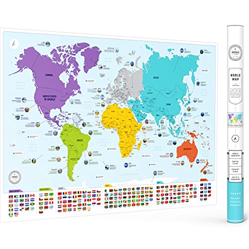
- Countries, flags, capitals, and continents
- Includes 50 interesting world facts
- Large matte poster for wall display
Best For: Classrooms and homeschool walls needing a clear reference map
Talking Poster Map – BEST LEARNING i-Poster My World
If you’re shopping for interactive world maps for classrooms, this talking poster is a simple way to add hands-on geography to lessons without any app or setup. Kids press countries directly on the mat to hear names, facts, and quiz prompts, which makes it easy to use for group review or independent learning.
Best For: Teachers, homeschoolers, and kids ages 5 to 12 who want an easy-to-use talking map for geography practice.
Pros:
- Press any of 92 countries to hear spoken names and facts.
- More than 1,000 facts cover capitals, flags, landmarks, languages, and population.
- Includes 10 quiz-and-learn modes for different learning styles.
- Batteries are included, and the mat offers 5 volume levels.
Cons:
- Designed for younger learners, so older students may outgrow the content quickly.
- Requires wall or floor space for use.
- Learning is tied to the built-in electronics rather than open-ended play.
This is a practical classroom-friendly option if you want an award-winning interactive map that is ready to use right away and can handle regular handling and wipe-clean cleanup.
Light-Up Globe Set – 9" Illuminated Educational Kids World Globe
This interactive globe is a good fit for classrooms that want a compact, all-in-one reference and night light. It shows countries, cities, and oceans in a spinning format, and it also switches to a constellation mode for added STEM learning.
Best For: Teachers, students, and homeschoolers who want a desktop globe that doubles as a light-up learning tool.
Pros:
- Combines a political world globe with a light-up constellation display.
- Includes an interactive geography card game and constellation guide.
- Compact 9-inch size works well on desks and shelves.
- LED illumination makes it useful as both a learning aid and night light.
Cons:
- Smaller desktop format offers less viewing area than a wall map.
- Best suited to table-top use rather than whole-class display.
- Some assembly and maintenance may be needed for lighting components.
For buyers who want interactive world maps for classrooms in a different format, this globe adds a useful mix of geography, astronomy, and desk-friendly display value.
Laminated Wall Reference – Rand McNally Classic Edition World Wall Map
This laminated wall map is a strong choice when you want a classroom-ready reference rather than an electronic toy. It is designed for clear, current geography study, with political boundaries, place names, and topographical relief that support everyday instruction.
Best For: Classrooms, offices, and home study spaces that need a durable, accurate wall reference map.
Pros:
- Large 50″ x 32″ format provides an easy-to-read classroom display.
- Laminated surface helps resist scuffs, fingerprints, and dry-erase marker.
- Africa-centered projection shows every continent and country intact.
- Topographical relief highlights major mountain ranges and landforms.
Cons:
- Not interactive or electronic.
- Requires wall space and hanging setup.
- More reference-focused than game-like for younger learners.
If your priority is a dependable visual aid, this map delivers a polished, durable classroom reference with current cartography and a projection that avoids common world-map distortions.
Bilingual Talking Poster – Qiaojoy Bilingual Interactive World Map for Kids
This bilingual poster is a useful pick for interactive world maps for classrooms where English and Spanish support matters. It uses an audio pen and recorded prompts to turn geography into a more personal activity, with facts, stories, and custom start-up sounds built in.
Best For: Bilingual learning, younger students, and classrooms that want a talking map with recording features.
Pros:
- Supports English and Spanish learning on one map.
- Includes an audio pen and recording function for custom use.
- Shares 3,500 facts about 195 countries.
- Covers country facts like flags, capitals, population, language, animals, and oceans.
Cons:
- Smaller listed dimensions may limit wall presence compared with larger posters.
- Requires battery-powered operation.
- Hands-on learning depends on the included pen and electronics.
For classrooms that want a more customizable talking map, this option stands out for bilingual support and a larger fact library than many basic geography posters.
Classroom Basics – Waterproof US & World Map Poster Set
If you want interactive world maps for classrooms that still work as simple wall references, this two-poster set gives you a clear, kid-friendly starting point. The United States and world maps use bright colors, readable fonts, and updated facts and figures to encourage discussion about geography, cultures, and landmarks.
Best For: Teachers, homeschoolers, and learning spaces that need durable, easy-to-read wall maps for young kids.
Pros:
- Includes both a U.S. map and a world map in one set
- Waterproof, tear-resistant plastic means no lamination is needed
- Dry-erase marker friendly for pointing out teaching moments
- Kid-focused design with colorful illustrations and clear labels
Cons:
- Not a true electronic interactive map
- Smaller 24″ x 16″ size may limit detail from a distance
This is a practical classroom decor pick if you want sturdy geography posters that can handle frequent use. It is more about visual engagement and hands-on marking than tech features, which makes it a solid low-maintenance option for younger learners.
Reference Pick – Laminated 24×36 World Classic Map
For classrooms that need a dependable world reference, this laminated wall map is a straightforward choice. It focuses on current political and topographic geography with shaded relief, making it useful for lessons where a clear, updated overview matters more than interactive features.
Best For: Educators, offices, and homes that want a durable, up-to-date world map for display and study.
Pros:
- Laminated UV coating adds durability and dry-erase use
- Shows 3D shaded relief for land and oceans
- Current world map suitable for educational use
- Large 24 x 36 inch format for wall display
Cons:
- Single-map format does not include U.S. geography
- Not an interactive learning toy or digital product
This is best viewed as a sturdy classroom reference rather than an activity-based teaching tool. If your priority is a large, updated world map that can stand up to repeated handling, it is an easy fit.
Hands-On Learning – Interactive World Map with Talking Pen
This is the closest fit for interactive world maps for classrooms if you want a hands-on learning tool instead of a static poster. The set includes a colorful map, talking pen, music card, and recordable greeting card, with sound-based features designed to make geography lessons more engaging for kids ages 5-12.
Best For: Classrooms, homeschool settings, and families looking for an interactive geography toy with audio-based learning.
Pros:
- Talking pen adds sound, prompts, and fun facts to the map
- Includes 3,500 facts, 15 quizzes, and three difficulty levels
- Covers all 195 countries with flags, capitals, animals, and more
- Roll-up design and protective tube help keep it in good shape
Cons:
- Designed for kids ages 5-12, so it may not suit older students
- Requires the talking pen for the interactive features to work
If you want geography to feel more like a game, this set offers much more engagement than a standard wall map. It stands out for active participation, quiz play, and audio cues that can support younger learners.
Search-and-Find Geography Pick – Kids World Map Poster with 150 Hidden Pictures
If you want interactive world maps for classrooms that double as wall art, this kids world map poster is built for hands-on, screen-free learning. The 33 x 24 inch layout includes 150 hidden pictures around the border, plus labeled map features like continents, oceans, the equator, tropics, and a compass rose to support basic geography skills.
Best For: Classroom displays, homeschool corners, and kids who enjoy seek-and-find learning activities.
Pros:
- 150 border illustrations create a search-and-find game that keeps kids engaged
- Includes map-learning details like continents, oceans, equator, tropics, and compass rose
- Thick gloss paper wipes clean and is designed to stay bright
- Updated 2026 version with current world information
Cons:
- It is a poster, so it is not a reusable sticker activity or game set
- Folded delivery may matter if you prefer a tube-shipped print
- Best suited for visual learning rather than tactile manipulation
This is a strong pick for teachers who want a colorful classroom map with a built-in activity. It balances decoration and learning well, especially for younger students who respond to find-and-identify games.
Hands-On Sticker Map Choice – Imagimake Mapology World Map Chart
For interactive world maps for classrooms that go beyond a simple poster, this Mapology chart turns geography into a hands-on activity. Kids place 100+ reusable stickers on the wall chart, then use the sand timer, spinners, and instruction book for five different ways to play while learning countries, continents, landmarks, and directions.
Best For: Classroom centers, homeschool lessons, and kids who learn best by moving pieces around.
Pros:
- Includes 100+ reusable stickers for repeated placement and repositioning
- Five play modes add variety with numbers, timing, spinners, atlas-style play, and compass practice
- Comes with a sand timer, two spinners, and an instruction book
- Built for classroom, homeschool, and family learning use
Cons:
- Requires active setup and supervision compared with a simple wall poster
- Sticker-based format may be less durable than a laminated chart for some classrooms
- Best for ages 5+, so it may skew young for older students
This is the most interactive option in the group and works well when you want students to participate instead of just look. It is especially useful for teachers who want a geography activity that can be revisited many times.
Classic Classroom Wall Map – Large World Map with Flags and Capitals
This large world map for the wall is a straightforward educational poster for classrooms that need clear reference material. It shows all countries, flags, capitals, and color-coded continents, and it adds 50 interesting facts for extra learning value without making the layout feel busy.
Best For: Classrooms, homeschool walls, and learners who want a readable reference map with extra facts.
Pros:
- Shows countries, flags, capitals, and color-coded continents
- Includes 50 interesting facts to support discussion and review
- Large 26 x 38 inch size works well as a wall display
- Matte finish gives it a clean, classroom-friendly look
Cons:
- Not interactive in the hands-on sense of sticker or game-based maps
- It is not a scratch map
- Students need to use it as a reference poster rather than an activity set
This is the best fit if you want an educational wall map that is easy to read from a distance and useful for daily reference. It leans more toward classic classroom utility than play-based interaction.
How We Picked the Best Interactive World Maps for Classrooms
We looked for classroom-ready maps that support real teaching goals: clear labeling, strong visual contrast, age-appropriate interactivity, and durable construction. For Interactive World Maps for Classrooms, that means more than novelty; it means a map students can actually use during lessons, centers, and independent review.
We also considered format variety. Some teachers need a wall map for whole-class instruction, while others benefit more from a desktop globe, talking map, or activity-based learning chart.
Quick Comparison
Wall maps are best for visibility and daily reference. Laminated posters offer the easiest wipe-clean setup for repeated use. Talking maps and pen-based products are better for guided practice and self-checking. Activity kits and reusable sticker maps work well for small groups, intervention, and take-home learning.
If you want a single focal point for the room, choose a larger wall map. If you want students to interact directly, look for audio prompts, games, or reusable pieces that keep them engaged without requiring constant teacher setup.
Key Buying Factors for Interactive World Maps for Classrooms
Age Range and Reading Level
Choose a map with text students can actually read. Younger learners often do better with large labels, bright colors, and simplified geography, while older students may need more detail such as capitals, borders, physical features, or flags.
Durability and Finish
Laminated, waterproof, and tear-resistant surfaces hold up better in busy classrooms. If students will handle the map frequently, durability matters as much as the educational content.
Size and Visibility
Larger formats are easier to see from across the room and work well for teacher-led instruction. Smaller maps can still be useful, but they usually fit better at centers or on individual desks.
Interactivity Type
Some maps teach through audio quizzes, while others use stickers, search-and-find activities, or visual prompts. Pick the format that matches how your class learns best. For Interactive World Maps for Classrooms, the most effective option is usually the one students will revisit often.
Content Accuracy and Scope
Make sure the map reflects current countries, borders, and political names. Extra features like flags, capitals, or topographical detail can be helpful, but only if they match your curriculum goals.
Who Should Buy Which Interactive World Maps for Classrooms?
Teachers looking for whole-class instruction should prioritize large wall maps with clean labeling. Homeschool families and early learners may prefer talking maps or game-based options that make practice feel playful. If you need flexible learning stations, activity maps and reusable sticker charts are a smart middle ground. For older students or general classroom decor, a laminated reference map may be the most practical choice.
The best pick is the one that fits your room, your students, and how often you plan to use it. A simple, durable map used regularly is usually more valuable than a feature-heavy option that stays on the wall untouched.