Choosing the right map can make geography lessons more visual, engaging, and memorable. The best world maps for homeschool help kids connect continents, countries, capitals, and regions without overwhelming the lesson.
In this roundup, we focused on maps that are clear, durable, and practical for home learning spaces, from laminated posters to puzzle-style options and illustrated designs.
Best 10 World Maps for Homeschool Picks for 2026
Classroom-Friendly Dual Map Set
USA & World Map Posters for Kids

- Includes both US and world maps in one set
- Waterproof, tear-resistant plastic construction
- Bright, easy-to-read design for young learners
Best For: Homeschool rooms needing durable, kid-friendly geography posters
Durable Laminated Pair

- Laminated 2-poster set for extra durability
- 18" x 29" size offers a larger wall display
- Includes both a world map and USA chart
Best For: Families wanting a simple laminated map pair for homeschool
Illustrated Learning Map
Rand McNally Kids' World Wall Map

- Large 50" x 32" world map for wall display
- Illustrated continents with plants, animals, and landmarks
- Labeled capitals, cities, and bodies of water
Best For: Homeschool families wanting a large illustrated geography reference
True-Size Geography Pair

- Equal Earth design shows true relative continent size
- Laminated 2-map set includes world and USA charts
- 18" x 29" size suits wall reference use
Best For: Homeschool lessons focused on accurate world geography
Interactive Puzzle Map
World Map Puzzle with Flags and Capitals

- 75 country-shaped pieces for hands-on geography
- Includes 65 flags and sticker learning elements
- 8 mm EVA foam build for sturdy use
Best For: Homeschool geography lessons with tactile learning
Current Wall Reference Map
Folded Political World Wall Map

- Completely current political world map
- 3D shaded relief for land and oceans
- Folded 24lb paper for portability
Best For: Home or homeschool reference walls
Durable Poster Map Set
Laminated World and USA Map Posters

- Includes both world and USA maps
- 3 MIL lamination for durability
- Tear-resistant 18 x 29 inch posters
Best For: Frequent-use homeschool wall displays
Premium Learning Map
Large World Map for Wall with Flags & Capitals
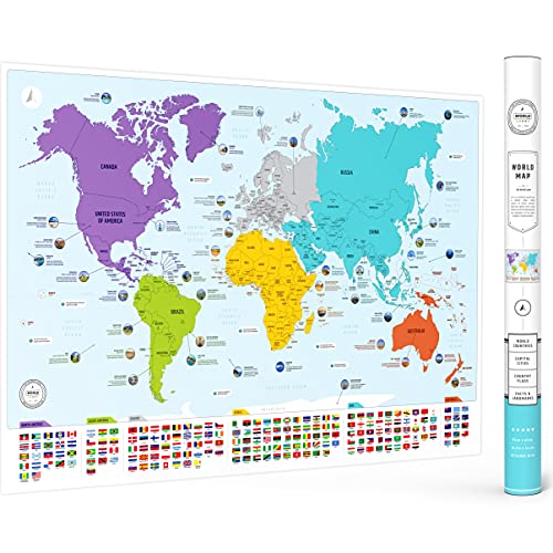
- Countries, flags, capitals, and continents
- 50 facts add extra homeschool value
- 26 x 38 inch matte poster for wall display
Best For: Homeschool families wanting a large, colorful geography teaching poster
Durable Two-Poster Set
Illustrated World & USA Laminated Maps

- World map and USA map together
- 3 MIL lamination for tear resistance
- 18 x 29 inch illustrated posters
Best For: Homeschoolers who need a sturdy map set for frequent use
Compact Laminated Pair
World and USA Wall Charts for Kids

- World and USA maps in one set
- Laminated for everyday wall use
- Compact 18 x 24 inch chart size
Best For: Small homeschool spaces needing a basic map set
Classroom-Friendly Dual Map Set – USA & World Map Posters for Kids
If you want world maps for homeschool that feel colorful, durable, and easy for younger learners to use, this 2-piece set is a practical pick. It combines a United States map and a world map in a bright, kid-friendly design with updated facts and clear labeling.
Best For: Homeschool spaces that need a durable, easy-to-read US and world map set for ages 4-8.
Pros:
- Includes both a US map and a world map in one classroom-ready set.
- Waterproof, tear-resistant plastic means no lamination is needed.
- Bright colors, crisp fonts, and kid-focused artwork help keep attention on geography.
- Can be written on with a dry erase marker and wiped clean with a damp cloth.
Cons:
- Poster size is smaller than some wall maps at 24″ x 16″ each.
- Unframed format may not suit buyers wanting a finished framed look.
Overall, this set is a strong choice if you want an affordable, long-lasting homeschool wall resource that can handle frequent use. It works especially well in spaces where both geography and simple visual learning matter.
Durable Laminated Pair – World Map Poster & USA Chart
For families comparing world maps for homeschool, this laminated two-poster set offers a simple, durable setup. The world map and USA chart come in a larger 18″ x 29″ format with 3 MIL lamination for added protection and tear resistance.
Best For: Homeschool buyers who want a laminated world map plus matching USA chart in a standard poster size.
Pros:
- Includes a world map poster and USA map chart together.
- 3 MIL lamination adds durability and tear resistance.
- 18″ x 29″ size gives you a larger display than many kid posters.
- Simple set is easy to hang in a classroom or homeschool area.
Cons:
- Listing notes are limited, so there are fewer detail cues about design features.
- Standard laminated poster format may be less interactive than write-on options.
This is a solid pick if your priority is a straightforward laminated map set that can stand up to regular handling. It suits homeschool spaces that want durability and a clean, no-fuss reference display.
Illustrated Learning Map – Rand McNally Kids' World Wall Map
If you’re looking for world maps for homeschool that feel educational and decorative at the same time, this illustrated wall map is a strong option. It uses a vibrant color palette, playful graphics, and labeled reference points to encourage lessons in geography and related subjects.
Best For: Homeschool families who want a large, visually engaging world map for kids’ learning spaces.
Pros:
- Large 50″ x 32″ format makes it easy to use as a wall display.
- Color-coded continents include native plants, animals, landmarks, and cultural icons.
- Labeled capitals, major cities, and bodies of water add learning reference points.
- Heavy paper construction adds extra durability for a printed wall map.
Cons:
- Paper rolled format may need framing or mounting for best display.
- Single-map format does not include a USA companion chart.
This map works well when you want a bigger visual centerpiece for daily homeschool geography lessons. It is especially appealing for kids who learn best from illustrations and colorful context clues.
True-Size Geography Pair – Equal Earth World Map Set
For homeschoolers who want world maps for homeschool with a more geography-focused layout, this laminated set stands out for its Equal Earth design. The world map shows continents at their true relative size, and the paired USA map gives you a matching reference for lesson time.
Best For: Homeschool lessons that need a laminated world map showing continents at true relative size.
Pros:
- Equal Earth world map design shows continents at true relative size.
- Includes both a world map and a USA map in one package.
- 3 MIL lamination adds durability and tear resistance.
- 18″ x 29″ poster size works well for wall reference use.
Cons:
- Design focus is more reference-oriented than decorative or playful.
- Limited product details leave fewer clues about added educational features.
This set is a smart option if you care about map accuracy and want a durable classroom-style format. It is especially useful in homeschool settings where geography lessons benefit from a more realistic continental layout.
Interactive Puzzle Map – World Map Puzzle with Flags and Capitals
If you want world maps for homeschool that feel more like hands-on learning than a wall display, this foam puzzle is a strong fit. It turns geography into an active activity with country-shaped pieces, flag stickers, and a Europe map, making it easy for kids to explore countries, capitals, and borders from home.
Best For: Homeschool families looking for a tactile, kid-friendly geography puzzle with flags and capitals.
Pros:
- Includes 75 country-shaped puzzle pieces for spatial awareness.
- Comes with 65 world flags plus stickers for learning national flags.
- Includes a Europe map for additional continental learning.
- Made from 8 mm EVA foam and designed to be sturdy and safe.
Cons:
- Best suited to hands-on learning rather than quick reference use.
- Assembly may take more effort than a simple poster map.
Overall, this is a practical homeschool geography tool for families who want an interactive, skill-building map activity. It is especially useful when you want kids to practice problem-solving while learning countries, capitals, and flags.
Current Wall Reference Map – Folded Political World Wall Map
For families comparing world maps for homeschool, this poster-style wall map is a straightforward reference option. It gives you a current political world map with 3D shaded relief on 24lb paper, so it works well when you need a simple, up-to-date map for study space or classroom wall use.
Best For: Homeschoolers who want an affordable, current wall map for everyday reference.
Pros:
- Political map format is useful for studying countries and borders.
- 3D shaded relief adds terrain visual detail.
- Folded edition is portable and easy to store.
- Printed on 24lb paper and described as completely current.
Cons:
- Paper format is less durable than laminated options.
- Folded packaging may not be ideal if you want a ready-to-hang display.
This is a practical pick if your homeschool setup needs a current wall map without extra features. It is best as a clean reference poster rather than a hands-on learning activity.
Durable Poster Map Set – Laminated World and USA Map Posters
If you need world maps for homeschool that can handle frequent use, this two-poster laminated set is a practical choice. It pairs a blue ocean world map with a USA map, and the 3 MIL lamination adds durability and tear resistance for daily study sessions.
Best For: Homeschool classrooms that want durable, easy-to-use map posters for repeated reference.
Pros:
- Includes both a world map and a USA map in one set.
- 3 MIL lamination helps protect against wear.
- Tear-resistant construction is better for active learning spaces.
- Poster size of 18″ x 29″ fits common wall display areas.
Cons:
- Offers less depth than a puzzle-based geography activity.
- Map details are not described as specialized for capitals or terrain relief.
For families who want a durable reference set rather than an activity toy, this is a sensible homeschool option. The laminated finish makes it a good fit for frequent handling, classroom walls, or study corners that see daily use.
Premium Learning Map – Large World Map for Wall with Flags & Capitals
If you want world maps for homeschool that do more than fill wall space, this large poster is built for everyday geography lessons. It combines countries, flags, capitals, color-coded continents, and 50 interesting facts in one colorful reference, making it easy to use during lessons or independent review.
Best For: Homeschool families who want a large, decorative teaching map with built-in geography details.
Pros:
- Includes countries, flags, capitals, and color-coded continents for structured learning.
- Features 50 interesting facts, adding extra teaching material to the poster.
- Large 26 x 38 inch size gives it strong visibility on a wall.
- Matte paper finish and protective tube packaging support durability.
Cons:
- This is not a scratch map, so it is not designed for tracking travel.
- It is a paper poster, so framing may be needed for the cleanest display.
- The detailed layout may feel busy if you prefer a very minimal map.
Overall, this is a practical choice for homeschool spaces that need a visual geography aid with both educational depth and colorful wall appeal. It works well as a lesson anchor, room decor piece, or quick-reference map for daily learning.
Durable Two-Poster Set – Illustrated World & USA Laminated Maps
2 Pack - World & USA Map for Kids [Illustrated] - 2 Poster Set (LAMINATED, 18" x 29")
Check Price On AmazonFor world maps for homeschool that need to handle regular use, this laminated 2-poster set offers a simple classroom-style setup. The package includes both a world map and a USA map, each sized at 18 x 29 inches and finished with 3 MIL lamination for added durability and tear resistance.
Best For: Families who want a durable laminated map set for repeated homeschool use.
Pros:
- Includes both a world map and a USA map in one set.
- 3 MIL lamination adds durability and tear resistance.
- 18 x 29 inch posters provide a clear, usable wall size.
- Illustrated format makes the set more engaging for kids.
Cons:
- Size is smaller than some large-format classroom posters.
- Designed as a poster set, so it does not include extra facts or labels mentioned in other options.
- Laminated finish may feel less decorative than a matte paper print.
This set is a strong pick if durability matters more than extra content. It gives homeschoolers two essential map references in a format that should hold up well to repeated handling and wall display.
Compact Laminated Pair – World and USA Wall Charts for Kids
If your homeschool setup needs a straightforward map pair, this laminated world-and-USA set covers the basics in a compact wall-chart format. At 18 x 24 inches, it is sized for smaller spaces while still giving kids a clear visual reference for geography lessons.
Best For: Small homeschool spaces that need a simple laminated map duo.
Pros:
- Includes both a world map and a USA map in one set.
- Laminated finish helps with everyday wall display.
- Compact 18 x 24 inch size works well in smaller rooms.
- Designed as a kid-friendly wall chart set.
Cons:
- No extra details like flags, capitals, or facts are listed.
- Smaller size may be less visible from farther away.
- Limited product details make it a more basic option overall.
This is a practical choice when you want a dependable map pair without paying for extra features. It fits neatly into homeschool rooms that need clear geography references without taking over the wall.
How We Picked the Best World Maps for Homeschool
For World Maps for Homeschool, we looked for strong readability, age-appropriate detail, and formats that work well in daily teaching. We prioritized maps that can handle repeated use, whether that means laminated surfaces, sturdy poster stock, or interactive puzzle elements. We also favored options that support a range of learning goals, from basic continent recognition to flags, capitals, and U.S. geography pairing.
Quick Comparison
The simplest choice is a laminated wall map set, which gives you a durable reference for daily lessons. Illustrated maps can be easier for younger learners because they feel less formal and often highlight animals, landmarks, or landmarks-style visuals. If you want active learning, puzzle maps add hands-on engagement. Larger wall posters are better when you want classroom-style visibility or plan to teach several children at once.
Key Buying Factors for World Maps for Homeschool
Age and Reading Level
Match the amount of detail to the child’s age. Younger learners usually do better with colorful, simplified maps that focus on continents and major regions. Older students can handle denser maps with capitals, borders, and finer geographic detail.
Durability
Laminated maps are ideal for frequent use because they resist tears and can often be marked with dry-erase tools. Paper posters can work well if they will stay framed or mounted out of reach. For high-traffic learning areas, durability matters just as much as design.
Visual Clarity
Look for clear fonts, strong contrast, and a layout that avoids clutter. The best World Maps for Homeschool make it easy to find information quickly, which keeps lessons moving and reduces frustration.
Learning Features
Extra details like flags, capitals, country outlines, and true-size projections can add value, but only if they support your lesson plan. A map with too much information may be less effective for early learners.
Size and Placement
Measure the wall or learning area before buying. A map that is too small loses educational value, while one that is oversized may dominate the room. The right size should be easy to read from the normal teaching distance.
Who Should Buy Which World Maps for Homeschool?
If you want a daily reference for mixed-age homeschooling, choose a laminated world-and-USA map set. If your child learns best through visuals, an illustrated world map is a strong fit. If you want hands-on learning and fine-motor practice, pick a puzzle map. For older students or multi-child lessons, larger wall maps with capitals and flags usually offer the best balance of detail and visibility.
For most families, the best choice is the map that matches both your teaching style and your child’s current level. In other words, the best World Maps for Homeschool are the ones your learners will actually use often enough to build real geographic confidence.