Interactive maps can turn geography into a hands-on activity kids actually want to revisit. The best models mix audio, quizzes, and visual learning to help children build confidence with places, landmarks, states, and capitals.
Whether you want a world map, a U.S. map, or a bilingual learning toy, this roundup focuses on options that are engaging, age-appropriate, and easy to use at home or in a classroom.
Best 10 Interactive Maps for Kids Picks for 2026
Talking World Map Poster
BEST LEARNING i-Poster My World

- 92 press-and-hear countries
- 1,000+ facts and 10 quiz modes
- Batteries included, 5 volume levels
Best For: Ages 5 to 12 learning world geography at home or in class
Video Globe Adventure
LeapFrog Magic Adventures Globe
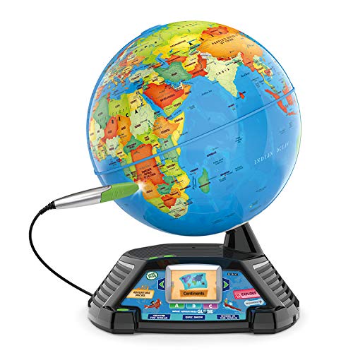
- 2.8-inch screen with BBC videos
- Thousands of facts plus 3 games
- Stylus-based globe learning
Best For: Age 5+ learners who like visual, hands-on geography
Talking USA Map Poster

- 50 states plus Washington, D.C.
- 4 study modes and 300+ questions
- Plays the Star-Spangled Banner
Best For: U.S. geography practice for ages 5 to 12
Sound Puzzle Map
Melissa & Doug USA Map Sound Puzzle

- Wooden, screen-free geography play
- Speaks capitals when pieces fit
- Teaches 50 states through puzzle discovery
Best For: Ages 5 to 8 learning U.S. geography by hands-on play
Illuminated STEM Globe Pick
9" Kids World Globe with Constellation Mode

- Spinning 9-inch globe shows countries, cities, and oceans.
- Switches to a glowing star map with 88 constellations.
- Includes a constellation guide and geography card game.
Best For: Kids and homeschoolers who want a globe with LED lighting and extra STEM activities.
USA Quiz Map Pick

- Talking map covers states, capitals, colonies, and Civil War topics.
- Two quiz levels plus an electoral vote game mode.
- Battery-powered set includes a touch pad and manual.
Best For: Kids learning U.S. geography and history through quiz-based play.
Bilingual World Map Pick
Talking World Map Poster for Kids

- English and Spanish support for bilingual learning.
- Audio pen includes recording features for custom play.
- Covers 3,500 facts across 195 countries.
Best For: Bilingual families and kids who want a talking wall-map style world geography tool.
World Geography Learning Set
Goldge Interactive World Map for Kids Ages 5-12

- Includes map, talking pen, piano card, and greeting card.
- Features 3,500 facts plus 15 quizzes with 3 difficulty levels.
- Roll-up glossy design is made for repeated use.
Best For: Kids ages 5-12 who want an engaging world geography toy.
Bilingual Space & Geography Poster Set
Talking USA Map Solar System Poster for Kids

- Pairs a USA map with a solar system poster.
- Bilingual English/Spanish audio supports learning.
- Includes 2,000+ facts and 3 game modes.
Best For: Kids ages 3-12 who like bilingual STEM-style learning.
Award-Winning Bilingual Map Bundle
Qiaojoy Interactive USA and World Map

- Includes both USA and world maps in one set.
- Bilingual pen supports recording and creative play.
- Offers 3,500 world facts, 2,000+ USA facts, and quizzes.
Best For: Kids ages 4-10 who want a bilingual USA and world map bundle.
Talking World Map Poster – BEST LEARNING i-Poster My World
If you want interactive maps for kids that feel like a true learning tool, this talking world map poster is built around touch-and-hear geography practice. Kids press any of 92 countries to hear names spoken aloud, then move through more than 1,000 facts and 10 quiz-and-learn modes that keep the activity fresh.
Best For: Curious kids ages 5 to 12 who want a wall or floor map for geography, listening, and general knowledge practice.
Pros:
- Press any of 92 countries for spoken names without needing an app or pen.
- Includes over 1,000 spoken facts covering capitals, flags, landmarks, languages, and population.
- Offers 10 quiz-and-learn modes to support repeated play and skill building.
- Comes ready to use with batteries included and 5 volume levels for home or classroom settings.
Cons:
- Requires wall or floor space because it is a large poster-style map.
- Works only as an electronic learning poster, not a 3D globe or puzzle.
- Best suited to ages 5 and up, so it is not for very young toddlers.
This is a strong pick for families who want a durable, screen-light geography activity with lots of repeat use. The award recognition and safety testing are also reassuring extras for a classroom or gift purchase.
Video Globe Adventure – LeapFrog Magic Adventures Globe
For families shopping for interactive maps for kids with more visual appeal, this globe mixes touch-based facts, quiz games, and video learning in one desktop toy. The built-in 2.8-inch screen shows BBC videos and animations, while the stylus-based globe unlocks thousands of facts and three interactive games.
Best For: Kids age 5+ who learn best from a globe with videos, guided games, and hands-on exploration.
Pros:
- Includes a 2.8-inch video screen with more than five hours of BBC content.
- Lets kids hear thousands of facts and interact with games using the stylus.
- Combines a globe, videos, and quiz-style activities for a varied learning experience.
- Comes with a stand, stylus, USB cord, and parent’s guide.
Cons:
- Uses 4 AA batteries for operation, and the included batteries are for demo use only.
- Bulkier than a flat map, so it takes more desk or shelf space.
- Best for one player, so it is less suited to group use.
This globe is a good choice if you want a more immersive format than a poster map. The screen, videos, and games add variety, making it appealing for kids who want geography to feel active and visual.
Talking USA Map Poster – BEST LEARNING i-Poster My USA
This U.S.-focused pick is one of the most practical interactive maps for kids who need state and capital practice. Children tap any state or Washington, D.C. to hear facts, then use the information, climate, knowledge, and fun fact modes to study the same state from different angles.
Best For: Kids ages 5 to 12 who are studying U.S. states, capitals, and classroom geography basics.
Pros:
- Covers all 50 states plus Washington, D.C. with spoken facts on touch.
- Includes four learning modes for repeating the same material in different ways.
- Offers more than 300 quiz questions with feedback and question replay.
- Plays the Star-Spangled Banner in two versions, adding an extra learning feature.
Cons:
- Limited to U.S. geography, so it is not a world map option.
- Requires wall or floor space because it is a poster-style mat.
- Uses AAA batteries, so it is not purely passive play.
For state-level learning, this map does a lot in a simple format. The mix of quizzes, spoken facts, and multiple study modes makes it a strong fit for homeschool or classroom use.
Sound Puzzle Map – Melissa & Doug USA Map Sound Puzzle
Melissa & Doug USA Map Sound Puzzle - Wooden Puzzle with Sound Effects (40 pcs)
Check Price On AmazonIf you prefer interactive maps for kids that stay screen-free, this wooden USA puzzle adds sound to hands-on state learning. Each piece activates a spoken state capital when placed correctly, giving children a simple way to connect map shapes with geography facts.
Best For: Hands-on learners ages 5 to 8 who want a screen-free U.S. states and capitals puzzle.
Pros:
- Wooden puzzle format supports tactile, screen-free play.
- Light-activated sensors speak the capital when a piece is placed correctly.
- Teaches the 50 states and their capitals through puzzle-based discovery.
- Compact and portable enough for floor play and gift giving.
Cons:
- Batteries are required but not included.
- Contains small parts, so it is not ideal for very young children.
- Only covers U.S. geography rather than world learning.
This puzzle is a good fit if you want a more traditional learning toy with a geography twist. It is especially appealing for younger kids who learn best by fitting pieces together and hearing instant feedback.
Illuminated STEM Globe Pick – 9" Kids World Globe with Constellation Mode
If you want interactive maps for kids that do more than sit on a shelf, this 9-inch illuminated globe adds a hands-on geography lesson to a desk, classroom, or bedroom. It shows countries, cities, oceans, and then switches into a glowing constellation map with 88 constellations for extra learning value.
Best For: Kids, homeschoolers, and teachers who want a spinning globe that doubles as an LED night light and STEM learning tool.
Pros:
- Shows political geography plus a light-up constellation mode with 88 constellations.
- Includes a constellation guide and an interactive geography card game for hands-on learning.
- Sturdy base and easy-to-read map details make it practical for home or classroom use.
- LED function turns it into a useful illuminated decor piece as well as a teaching aid.
Cons:
- Requires assembly care and maintenance guidance for bulb replacement.
- More of a globe-and-night-light combo than a flat wall map.
This is a good pick if you want a multi-use educational globe that keeps geography visually engaging. The mix of map learning, constellation mode, and game-based STEM activities makes it especially useful for younger learners who respond well to interactive visuals.
USA Quiz Map Pick – myTouch Talking Map Game
This interactive map for kids is built around U.S. geography and history, with two talking map views, quiz gameplay, and multiple learning modes. It is designed to make states, capitals, the 13 colonies, the Civil War, and even electoral votes easier to learn through guided play.
Best For: Kids who want a U.S.-focused talking map with quiz challenges and history-based learning modes.
Pros:
- Includes two talking maps covering the 13 original colonies and the Civil War.
- Offers two quiz difficulty levels for more flexible learning.
- Race-to-the-White-House mode adds an electoral vote game element.
- Battery-powered design includes the talking touch pad and instruction manual.
Cons:
- Focused on the United States rather than world geography.
- Requires 3 AAA batteries, which are included but still need replacement over time.
This is a strong choice if your goal is to build U.S. geography knowledge with a more structured quiz format. The combination of talking prompts, history content, and game modes gives it a classroom-friendly feel without losing the play aspect.
Bilingual World Map Pick – Talking World Map Poster for Kids
For families looking for interactive maps for kids in a poster format, this bilingual world map adds talking learning, audio recording, and a large amount of geography content. It covers 195 countries and is designed to support English and Spanish learning in a simple wall-map layout.
Best For: Bilingual families and young learners who want a talking world map poster with recording features.
Pros:
- Bilingual English and Spanish support makes it useful for dual-language learning.
- Includes an audio pen with recording features for personalized play and storytelling.
- Teaches 3,500 facts across 195 countries, including capitals, flags, languages, oceans, and more.
- Poster format keeps it lightweight and easy to display.
Cons:
- Poster-style design is less tactile than a physical globe or tabletop toy.
- Requires battery power for the talking functions.
This map stands out for combining language learning with broad world geography coverage. If you want a wall-mounted option that feels interactive without taking up much space, it offers a strong balance of education and flexibility.
World Geography Learning Set – Goldge Interactive World Map for Kids Ages 5-12
If you want interactive maps for kids that feel more like play than study, this Goldge world map set is built to keep attention with sound, touch, and quizzes. It combines a colorful roll-up map with a talking pen, piano music card, and recordable greeting card, making it a practical choice for home learning or classroom use.
Best For: Kids ages 5-12 who enjoy hands-on geography learning with audio feedback and quiz games.
Pros:
- Includes a large world map, talking pen, piano music card, and recordable greeting card.
- Offers 3,500 facts, 15 quizzes, and three difficulty levels for geography practice.
- Tap-to-hear features add facts, world music, and voice prompts.
- Durable, glossy, roll-up design helps it hold up over time.
Cons:
- Designed for ages 5-12, so it may be less suitable for younger preschoolers.
- Requires a child’s interest in audio-based learning to get the full benefit.
This is a strong pick if you want an educational map toy that mixes geography facts with interactive play. The included extras and built-in quizzes give it more value than a basic wall chart, especially for families looking for a giftable learning set.
Bilingual Space & Geography Poster Set – Talking USA Map Solar System Poster for Kids
This bilingual set stands out among interactive maps for kids by pairing a talking USA map with a solar system poster, so children can explore geography and space in one purchase. The touch-activated format, English/Spanish audio, and included audio pen make it a versatile learning tool for preschool through early elementary ages.
Best For: Kids ages 3-12 who want bilingual learning and a mix of geography and space science.
Pros:
- Combines a USA map and solar system poster in one educational set.
- Bilingual English/Spanish audio supports language development.
- Includes 10 interactive features and over 2,000 fun facts.
- Three game modes add memory, matching, and reflex practice.
Cons:
- It is a poster-based set, so it may feel less map-focused than a dedicated world map toy.
- Uses battery-powered audio components, which adds an ongoing maintenance step.
If your goal is to stretch one learning toy across more than one subject, this set offers a lot of variety. The bilingual audio and game modes make it appealing for kids who learn best through repetition, sounds, and active play.
Award-Winning Bilingual Map Bundle – Qiaojoy Interactive USA and World Map
For families comparing interactive maps for kids, this Qiaojoy bundle offers both a USA map and a world map in one set, plus bilingual learning and a recording-enabled stylus. It is designed for children who like to explore facts through touch, quizzes, and creative audio play, while the award recognition adds confidence for gift buyers.
Best For: Kids ages 4-10 who want both USA and world geography in a bilingual format.
Pros:
- Includes both a USA map and a world map in one package.
- Bilingual English/Spanish learning with a DIY magic wand and recording features.
- Offers 3,500 world facts and 2,000+ USA facts.
- Three quiz levels help make learning more interactive.
Cons:
- It is a bundle, so it may be more than needed if you only want one map.
- The compact flat-map design may be less display-like than a large wall poster.
This is a strong all-in-one choice if you want broader geography coverage without buying separate products. The bilingual audio and recording options make it especially appealing for kids who enjoy both learning and creative play.
How We Picked the Best Interactive Maps for Kids
We looked for maps that make learning active rather than passive. Strong picks offer clear narration, age-appropriate quiz modes, durable materials, and content that matches common learning goals such as country recognition, state/capital memorization, and basic world geography. We also favored products that are simple enough for children to use independently, with enough variety to stay interesting over time.
Quick Comparison
When comparing Interactive Maps for Kids, start with the learning focus: world geography, U.S. geography, or a mix of both. Then consider how your child learns best. Talking posters are great for repetitive practice, globes add a 3D spatial element, and puzzle-style maps can be especially helpful for tactile learners. Bilingual options can also be a strong choice for families supporting language exposure.
Key Buying Factors for Interactive Maps for Kids
Age and Reading Level
Look for maps that match your child’s developmental stage. Younger kids usually benefit from simple prompts, sounds, and visual identification. Older children may prefer richer fact libraries, faster quiz modes, and more detailed content.
Topic Coverage
Not every educational map teaches the same material. Some focus on the USA, including states and capitals, while others cover continents, countries, landmarks, or even bonus topics like space. Choose the map that aligns with what your child is learning now.
Interactivity and Engagement
The best Interactive Maps for Kids use clear audio, responsive touch or pen controls, and quiz gameplay that encourages repeat practice. Features like multiple difficulty levels, recordable messages, or bilingual narration can add long-term value.
Size, Placement, and Durability
Consider where the map will live. Wall posters are ideal for bedrooms and homeschool spaces, while globes and puzzle boards work well on desks and tables. If the product will be handled often, durable construction matters just as much as the educational content.
Who Should Buy Which Interactive Maps for Kids?
Choose a world map if you want broad geography exposure, a U.S. map if your child is focused on states and capitals, and a globe if you want a more spatial, hands-on learning experience. Puzzle-based options suit tactile learners, while talking posters and pen-based systems are best for kids who enjoy independent quiz play. If you want extra versatility, bilingual models can be especially useful for multilingual homes and classrooms.
In the end, the best choice depends on your child’s learning style, current curriculum, and how much interaction you want from the map. A well-chosen educational map can make geography feel less like memorization and more like discovery.