Interactive maps can turn U.S. geography into a hands-on, repeatable learning experience. For many kids, that means better recall of states, capitals, and regional landmarks.
This roundup focuses on kid-friendly options that combine education with engagement, from talking posters to puzzles and classroom-ready maps.
Best 10 Interactive United States Maps for Kids Picks for 2026
Talking poster with rich geography content

- 50 states plus Washington, D.C. with spoken facts
- 4 learning modes and 300+ quiz questions
- National anthem playback and 5 volume levels
Best For: ages 5 to 12 who want a wall-hanging U.S. geography learner
Reusable dry-erase map for practice
SCRIBBLEDO United States Map Whiteboard

- 11"x14" whiteboard with a detailed U.S. map
- Dry erase surface for easy reuse
- Useful for school, home, office, and travel planning
Best For: teachers and students who want a simple wipe-clean map for practice
Bilingual map set with U.S. and world learning
Qiaojoy Bilingual Interactive Kids Map

- USA map plus world map in one set
- English/Spanish support with recording feature
- Over 2,000 U.S. facts and quiz games
Best For: families wanting bilingual geography play with both U.S. and world maps
History-rich talking map game

- 1000 facts plus states and capitals
- Two difficulty levels and quiz gameplay
- Includes 13 colonies, Civil War, and election mode
Best For: older kids who want U.S. geography with history and game-based learning
Hands-On Geography Pick

- 43 magnetic pieces for all 50 states
- Includes paper outline and regional details
- Works on fridges and whiteboards
Best For: Preschool and elementary kids who learn best with tactile map play
Classic Wooden Learning Choice
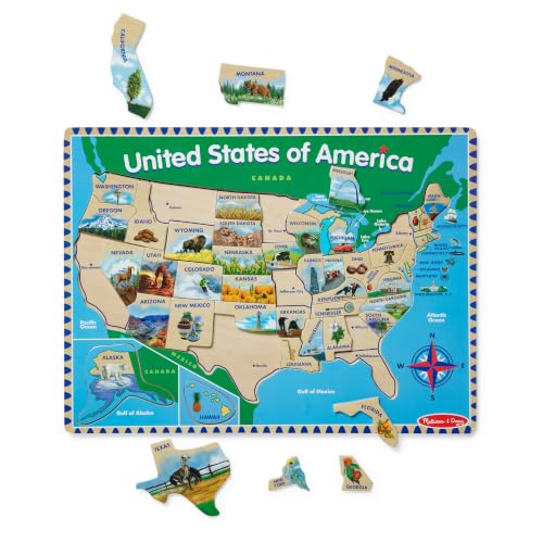
- Shows state capitals under the pieces
- Adds fun facts on the board back
- Encourages logical thinking and patience
Best For: Kids ages 5+ who enjoy wooden puzzles and geography practice
Bilingual Interactive Learning Set

- Touch-activated audio in English and Spanish
- Includes 10 features and 2000+ facts
- Adds games plus a solar system poster
Best For: Ages 3-12 who like audio-based bilingual learning
Hands-On Preschool Pick
Lift & Learn USA Map Puzzle for Preschoolers

- 40-piece map puzzle with all 50 states
- Raised textures help small hands grip pieces
- Supports fine motor skills and independent play
Best For: Preschool kids ages 3+ who like tactile puzzles
Best Audio Learning Map
Bilingual Talking USA Map Poster for Kids

- Bilingual English/Spanish talking map poster
- About 2000 facts with 10 interactive features
- Three game modes add challenge and variety
Best For: Kids ages 3-12 who like audio-based geography games
Most Balanced Puzzle Option
70-Piece USA Map Floor Puzzle for Kids

- 70-piece floor puzzle with large, sturdy pieces
- Teaches all 50 states, capitals, and landmarks
- Supports problem-solving and spatial reasoning
Best For: Kids ages 4-8 ready for a larger geography puzzle
Talking poster with rich geography content – BEST LEARNING i-Poster My USA
If you’re comparing interactive united states maps for kids, this talking poster stands out for its breadth of content. It covers all 50 states and Washington, D.C. with spoken capitals, largest cities, landmarks, quizzes, and even the national anthem, so it works well for both casual discovery and more structured geography review.
Best For: Kids ages 5 to 12 who need a rich, wall-ready U.S. geography tool for home or classroom use.
Pros:
- 51 press points plus spoken facts about capitals, cities, and landmarks
- Four learning modes and 300+ quiz questions for varied practice
- Plays the national anthem in two versions for sing-along learning
- Includes 5 volume levels and comes ready to play with batteries included
Cons:
- Uses a manual, touch-based format rather than a screen or app
- Focused on U.S. geography, so it won’t cover broader world learning
- Best suited to children old enough to follow quiz prompts and replayed questions
This is a strong pick if you want an educational poster that does more than label states. With multiple learning modes and a large quiz bank, it has enough variety to stay useful as kids grow.
Reusable dry-erase map for practice – SCRIBBLEDO United States Map Whiteboard
For buyers who want interactive united states maps for kids without electronics, this dry erase board offers a simple hands-on format. The 11″x14″ U.S. map gives students a clean visual reference for lessons, labeling practice, travel planning, and quick classroom discussions.
Best For: Teachers, parents, and students who want a reusable U.S. map board for writing, pointing, and practice.
Pros:
- Dry erase surface makes it easy to wipe clean and reuse
- Detailed U.S. map with state boundaries for geography lessons
- Compact 11″x14″ size works well on a wall or desk area
- Useful for school, office, home, and travel-planning use
Cons:
- Does not include audio, quizzes, or other digital learning features
- Smaller format may not suit larger group instruction
- Best for guided practice rather than self-directed play
This is a practical option if you want a reusable map that supports active teaching instead of electronic features. It is straightforward, versatile, and easy to reset for the next lesson.
Bilingual map set with U.S. and world learning – Qiaojoy Bilingual Interactive Kids Map
If you want interactive united states maps for kids with extra flexibility, this bilingual set adds both a U.S. map and a world map in one package. It includes English and Spanish learning support, a recording feature, and quiz games, making it a good fit for families who want a more customizable learning experience.
Best For: Kids ages 4 to 10 who want bilingual geography play and a map set that includes both U.S. and world learning.
Pros:
- Includes both a USA map and a world map
- Bilingual English/Spanish learning support
- Recording function and personalized startup sound add creativity
- More than 2,000 U.S. facts plus quiz games for active learning
Cons:
- Uses electronic components, so it is less simple than a non-powered map
- Smaller format than wall-sized map posters
- Learning focus is spread across both U.S. and world content
This set is a good match if you want more than a single-purpose U.S. map. The bilingual features and included world map make it especially appealing for households that value variety and language practice.
History-rich talking map game – Zanzoon myTouch USA Map Game
Among interactive united states maps for kids, this one leans hardest into history and game play. It combines states and capitals with 13 colonies and Civil War content, plus quiz modes and a White House race game that makes it a strong choice for older kids who want more challenge.
Best For: Kids ages 6 and up who want a more advanced U.S. map game with history and election-themed play.
Pros:
- Includes 1000 facts with states and capitals coverage
- Two difficulty levels support different learning stages
- Features 13 colonies, Civil War content, and two interactive views
- Race to the White House mode adds an election-process game element
Cons:
- More history-heavy than simpler beginner maps
- Requires batteries and manual interaction rather than screen-based play
- May be less ideal for very young children just starting with states and capitals
This is a smart pick if you want a U.S. map that goes beyond basic geography. The added history and game modes give it more staying power for kids who are ready for a bigger challenge.
Hands-On Geography Pick – Magnetic U.S. Map Puzzle
If you’re comparing interactive united states maps for kids, this magnetic U.S. map puzzle is a strong hands-on choice for early geography practice. The 43-piece set helps children match state names and shapes while also introducing landmarks, plants, and animals from different regions.
Best For: Preschool and elementary kids who learn best with tactile, screen-free map play.
Pros:
- 43 magnetic pieces show all 50 states plus regional landmarks, plants, and animals.
- Includes a paper outline to help kids learn where each state goes.
- Works on fridges, whiteboards, and other magnetic surfaces.
- Supports geography, critical thinking, spatial relationships, and fine motor skills.
Cons:
- Designed for ages 48 months and up, so it is not ideal for very young toddlers.
- Small magnetic pieces may require supervision.
Overall, this is a practical starter map for families and classrooms that want a simple, visual, and interactive way to build U.S. geography knowledge.
Classic Wooden Learning Choice – USA Map Wooden Puzzle
For families looking at interactive united states maps for kids, this wooden puzzle offers a classic, screen-free way to learn state locations and capitals. The puzzle board identifies state capitals under the pieces and adds fun facts on the back for extra learning during play.
Best For: Kids ages 5+ who enjoy wooden puzzles and structured geography learning.
Pros:
- State capitals are identified under the puzzle pieces.
- Includes fun facts on the back of the board for added learning value.
- Encourages logical thinking, goal-setting, and patience.
- Wooden construction makes it a durable, hands-on option.
Cons:
- Contains small parts, so it needs supervision for younger children.
- Best suited to older preschoolers and grade-school kids rather than toddlers.
This is a solid pick if you want a familiar puzzle format that builds geography skills in a calm, engaging, and educational way.
Bilingual Interactive Learning Set – Talking USA Map Poster
If you want interactive united states maps for kids with extra variety, this bilingual talking poster adds audio, games, and a second subject area in one set. Children can explore U.S. geography through touch-activated features while also learning about the solar system with the included poster and audio pen.
Best For: Ages 3-12 who like audio-based learning, bilingual content, and classroom-style activities.
Pros:
- Touch-activated features deliver sounds and fun facts in English and Spanish.
- Includes 10 interactive features and over 2000 facts about the U.S. and space.
- Three game modes support memory, matching, and reflex practice.
- Comes with an audio pen and DIY magic wand for more interactive play.
Cons:
- Requires batteries for operation.
- Focuses on both geography and space, so it may be broader than some buyers want.
This set stands out for families who want a more immersive learning tool with audio feedback, bilingual content, and multiple ways to keep kids engaged.
Hands-On Preschool Pick – Lift & Learn USA Map Puzzle for Preschoolers
If you want interactive united states maps for kids that feel hands-on and age-friendly, this 40-piece USA map puzzle is a simple place to start. The raised, brightly colored pieces are easy for little hands to grab, and the activity supports fine motor skills, hand-eye coordination, and problem-solving while encouraging independent play.
Best For: Preschoolers ages 3+ who enjoy tactile, screen-free learning and beginner geography play.
Pros:
- 40-piece puzzle featuring all fifty states
- Raised textures make pieces easier to handle
- Supports motor development, research, and thinking skills
- Portable, manual puzzle board for independent play
Cons:
- Only covers basic map-puzzle learning rather than audio or electronic features
- Best suited to younger children and beginner skill levels
Overall, this is a straightforward educational puzzle for families who want a tactile introduction to U.S. geography. It keeps the learning simple and physical, which makes it a strong fit for early learners.
Best Audio Learning Map – Bilingual Talking USA Map Poster for Kids
For shoppers comparing interactive united states maps for kids, this bilingual talking map stands out for turning geography into an audio-driven activity. It includes 10 interactive features, about 2000 fun facts, and game modes that move from memory practice to matching and reflection, so kids can explore states, capitals, culture, and more at their own pace.
Best For: Kids ages 3-12 who learn best through sound, repetition, and bilingual English/Spanish play.
Pros:
- Bilingual English and Spanish learning support
- 10 interactive features with about 2000 fun facts
- Three game modes for progressive challenge
- Recording function and personalized startup sound
Cons:
- Requires 2 AAA batteries
- Poster-style format is less hands-on than a puzzle
This is a strong pick if you want a more immersive geography toy with audio, quiz-style play, and extra content beyond states and capitals. It offers the most variety for kids who stay engaged with talking educational toys.
Most Balanced Puzzle Option – 70-Piece USA Map Floor Puzzle for Kids
If you want interactive united states maps for kids in a classic puzzle format, this 70-piece floor jigsaw is built for learning through assembly. It focuses on problem-solving, observation, spatial reasoning, concentration, and memory, while the large pieces and colorful state illustrations make it a practical family or classroom activity.
Best For: Kids ages 4-8 who want a bigger, more challenging USA map puzzle with state and capital learning.
Pros:
- 70 large pieces with a floor-puzzle layout
- Teaches all 50 states, capitals, and landscapes
- Supports problem-solving, spatial reasoning, and memory
- Made from sturdy 2mm chipboard with safety testing noted
Cons:
- More challenging than a simple beginner map puzzle
- No electronic or talking features
This puzzle is a good middle-ground choice for kids who are ready for a bigger geography challenge without moving into electronic learning toys. It offers solid educational value and enough size to work well for shared play.
How We Picked the Best Interactive United States Maps for Kids
We focused on products that help children learn U.S. geography in a clear, age-appropriate way. The strongest options offer a mix of state identification, capital recognition, quizzes, sounds, or puzzle-based reinforcement. We also favored durable materials, simple instructions, and formats that work well for home learning, classrooms, and travel-friendly play.
Quick Comparison
Talking posters are best for audio-based learning and independent practice. Puzzle maps are better for tactile learners who benefit from matching pieces and spatial memory. Classroom dry-erase maps can be useful for repeated labeling and teacher-led lessons. If you want the broadest educational value, look for Interactive United States Maps for Kids that combine facts, quizzes, and visual reinforcement.
Key Buying Factors for Interactive United States Maps for Kids
Age and Skill Level
Choose simpler lift-and-learn or large-piece puzzles for preschool and early elementary ages. Older kids may benefit more from quiz-style maps with capitals, spelling, and timed challenges.
Learning Format
Consider whether your child learns best by hearing, touching, or reading. Talking maps support auditory learners, while puzzles and magnetic boards support hands-on learners.
Content Depth
Some maps cover only states and capitals, while others include landmarks, facts, or multiple difficulty levels. If your goal is long-term use, a map with layered content usually offers better value.
Durability and Setup
For classroom or daily home use, prioritize sturdy construction, wipe-clean surfaces, and pieces that are easy for small hands to manage. Wall posters should also be sized appropriately for visibility.
Who Should Buy Which Interactive United States Maps for Kids?
Parents of younger children should lean toward puzzles and lift-and-learn designs that make geography feel like play. Homeschool families may prefer talking maps or magnetic boards for repeat lessons and quick review sessions. Teachers will likely get the most flexibility from dry-erase or poster-style options that support group instruction. For kids who enjoy games and quizzes, Interactive United States Maps for Kids with spoken prompts and multiple difficulty settings are often the most engaging choice.