Interactive maps can turn geography from memorization into hands-on learning. For homeschool families, the right map helps kids explore states, countries, landmarks, and capitals in a way that sticks.
Below, you’ll find the best interactive maps for homeschool in 2026, chosen for clarity, engagement, durability, and age-appropriate learning value.
Best 10 Interactive Maps for Homeschool Picks for 2026
Top Bilingual Pick

- Bilingual English and Spanish support
- 10 interactive features with 2,000 facts
- Three game modes for growing skills
Best For: Homeschoolers teaching U.S. geography in two languages
STEM Night-Light Globe
Illuminated Educational Kids World Globe

- Maps countries, cities, and oceans
- Light-up constellation mode with 88 constellations
- Includes a geography card game and guide
Best For: Families wanting one globe for geography and astronomy
Hands-On Puzzle Map
Learning Resources Magnetic U.S. Map Puzzle

- 43 magnetic pieces for all 50 states
- Includes landmarks, plants, and animals
- Supports spatial and fine motor skills
Best For: Young learners who like tactile geography activities
History Quiz Map

- 1,000 facts with states and capitals
- Quiz mode with two difficulty levels
- Includes colonies, Civil War, and election play
Best For: Older homeschoolers studying U.S. history and civics
Interactive Sticker Learning
Imagimake Mapology World Map Chart

- 100+ reusable stickers for repeated practice
- Five different ways to play and learn
- Built for homeschool and classroom wall use
Best For: Homeschool families with kids ages 5+ who learn best by doing
Write-On Wall Maps
Illustrated World & USA Map Set
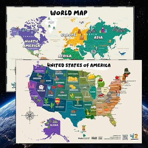
- Bundle includes both world and USA maps
- Laminated surface works with dry-erase markers
- Large 24" x 36" posters for easy wall viewing
Best For: Homeschoolers wanting reusable geography posters for daily review
Hands-On USA Geography
Imagimake Mapology USA Map Chart

- Covers all 50 states with fun facts
- 100+ reusable stickers plus timer and spinners
- Good fit for homeschool and classroom use
Best For: Kids ages 5+ learning U.S. states through play
Waterproof Classroom Duo
US and World Map Posters for Kids

- Includes both US and world maps in one set
- Waterproof, tear-resistant plastic construction
- Dry-erase marker friendly for homeschool use
Best For: Homeschool rooms needing durable wall reference maps
Talking Map Learning Station

- 51 pressable locations with spoken facts
- 300+ quiz questions and 4 learning modes
- Builds geography, memory, and concentration
Best For: Audio-based homeschool geography lessons
Flash Card Puzzle Explorer

- 50 foam state pieces plus 52 game cards
- Covers 750+ facts about states and capitals
- Includes swipe-and-reveal and quiz-style play
Best For: Older kids doing hands-on US geography study
Top Bilingual Pick – Qiaojoy V2 Interactive Map
If you want interactive maps for homeschool that keep kids actively involved, this bilingual U.S. map is built for hands-on learning. It combines states, capitals, history, culture, and fun sound effects, so lessons feel more like guided discovery than memorization.
Best For: Homeschool families teaching U.S. geography in both English and Spanish who want a highly interactive wall map.
Pros:
- Bilingual English and Spanish learning support
- Includes 10 interactive features and 2,000 fun facts
- Offers three game modes that progress from easy to challenging
- Recording function and customizable startup sound add flexibility
Cons:
- Requires 2 AAA batteries
- Focused on U.S. geography rather than broader world studies
- Best suited to wall display and guided use
This is a strong choice for families who want an award-winning, feature-rich map that can grow with a child’s geography skills. The mix of audio, games, and bilingual content makes it especially useful for repeat homeschool lessons.
STEM Night-Light Globe – Illuminated Educational Kids World Globe
For families comparing interactive maps for homeschool, this illuminated globe stands out because it blends geography and astronomy in one desktop piece. Kids can study countries, cities, and oceans during the day, then switch to a constellation display at night for a different kind of learning.
Best For: Homeschoolers who want a dual-purpose globe that supports both geography lessons and constellation study.
Pros:
- Shows countries, cities, and oceans in vivid detail
- Includes 88 constellations in light-up mode
- Comes with a constellation guide and interactive geography card game
- Works as both a learning tool and LED night light
Cons:
- Not a flat map, so it may not suit every geography lesson
- Requires assembly and occasional bulb maintenance
- Best for desktop use rather than wall display
This globe is a practical option if you want one item that can anchor both science and geography instruction. Its illuminated design also makes it easy to keep in a bedroom, classroom, or homeschool workspace.
Hands-On Puzzle Map – Learning Resources Magnetic U.S. Map Puzzle
If your homeschool setup works best with tactile activities, this magnetic U.S. map puzzle offers a simple, interactive way to learn geography. The 43 pieces help kids match state names and shapes while also introducing landmarks, plants, and animals from across the country.
Best For: Younger homeschool learners who benefit from puzzle-style geography practice and magnetic play.
Pros:
- 43 magnetic pieces cover all 50 states
- Includes landmarks, plants, and animals for broader learning
- Supports geography, spatial relationships, and fine motor skills
- Works on fridges and other magnetic surfaces
Cons:
- Only covers the United States
- Requires a magnetic surface for display play
- Less feature-heavy than talking or audio-based maps
This is a straightforward and practical pick for hands-on homeschool geography. It’s especially appealing if you want a reusable puzzle that doubles as a visual reference on a fridge or whiteboard.
History Quiz Map – Zanzoon myTouch USA Map Game
For interactive maps for homeschool with a strong history angle, this talking USA map goes beyond basic states and capitals. It adds quizzes, electoral vote play, and focused U.S. history topics like the 13 original colonies and the Civil War, which makes it useful for older children.
Best For: Homeschoolers who want an interactive U.S. map with history content and quiz-based learning.
Pros:
- Covers 1,000 facts, states, and capitals
- Includes two difficulty levels for quiz play
- Features game modes tied to electoral votes and presidential elections
- Includes content on the 13 original colonies and the Civil War
Cons:
- Requires 3 AAA batteries
- Only supports two players
- Best suited to U.S. studies rather than general world geography
This is a good fit for homeschool families who want a map that feels closer to a study game than a wall chart. The combination of history, geography, and quiz modes gives it a more advanced learning profile.
Interactive Sticker Learning – Imagimake Mapology World Map Chart
If you want interactive maps for homeschool, this world map chart turns geography into a hands-on activity instead of a memorization task. Kids place reusable stickers for monuments, animals, and foods, then use the included timer, spinners, and instruction book to practice continents, directions, and map recognition in different ways.
Best For: Homeschool families who want a playful world geography activity for ages 5+.
Pros:
- Includes 100+ reusable stickers for repeated geography practice
- Five play modes add variety: numbers, timer races, spinner activities, atlas-style learning, and compass use
- Supports memory, focus, problem-solving, fine motor skills, and spatial understanding
- Designed for wall display and classroom or homeschool use
Cons:
- Requires wall space for the chart setup
- Best suited to guided learning and interactive play, not independent study only
This is a strong pick if you want a geography kit that feels like a game while still teaching real map concepts. The reusable stickers and multiple activities help keep younger kids engaged through repeated use.
Write-On Wall Maps – Illustrated World & USA Map Set
For families looking for interactive maps for homeschool, this World Map and USA Map bundle offers a clean, visual way to teach geography on the wall. The laminated write-on, wipe-off surface makes it easy to add dry-erase practice, while the large 24″ x 36″ format helps kids see countries, states, landmarks, animals, and other details clearly.
Best For: Homeschool rooms that need durable, reusable wall maps for both world and U.S. geography.
Pros:
- Includes both a world map and a USA map in one bundle
- Laminated, waterproof, tear-resistant, and write-on/wipe-off
- Large format is easy to view from a distance
- Designed specifically for kids, classrooms, and homeschool environments
Cons:
- Does not include stickers, timers, or game pieces
- Learning style is more visual and dry-erase based than hands-on game based
This set is a practical choice if you want simple, durable maps that can stay on the wall and support everyday geography review. It leans more toward clear visual learning than activity-based play, which may suit some homeschool setups better than others.
Hands-On USA Geography – Imagimake Mapology USA Map Chart
If you’re comparing interactive maps for homeschool, this USA map chart adds a lot of activity to state-level learning. Kids use reusable stickers, spinners, and a sand timer to explore all 50 states, landmarks, wildlife, and cultural icons in a way that keeps the lesson moving.
Best For: Families teaching U.S. geography who want a game-style map activity for ages 5+.
Pros:
- Covers all 50 states with fun facts and map practice
- Includes 100+ reusable stickers plus a spinner and sand timer
- Multiple play options help reinforce states, regions, landmarks, and capitals
- Works well for homeschool activities, classroom games, and family learning
Cons:
- Focused only on U.S. geography, not world geography
- Assembly is required with the included rods
This is a solid pick if your homeschool curriculum is focusing on the United States and you want a more interactive option than a standard wall map. The repeated sticker-and-quiz format makes it easier to revisit states without turning the lesson into rote drill.
Waterproof Classroom Duo – US and World Map Posters for Kids
If you want interactive maps for homeschool that are simple, visual, and durable, this 2-piece United States and world map poster set is a practical pick. The colorful, kid-friendly artwork is designed to help children notice landmarks, regions, and countries while keeping the lesson easy to follow at home.
Best For: Homeschool spaces that need affordable wall maps for geography, discussion, and daily reference.
Pros:
- Includes both a US map and a world map for broader geography lessons.
- Waterproof, tear-resistant plastic construction helps it hold up to repeated use.
- Dry-erase marker friendly for pointing out teaching notes and quick reviews.
- Bright, readable design works well in homeschool rooms and play spaces.
Cons:
- These are poster-style maps, so they do not provide hands-on quizzes or audio.
- Unframed format may require separate mounting or display supplies.
This set is a strong fit if you mainly want visual geography support that can stay up year-round. It is better for reinforcing lessons than for fully interactive play, but the durable materials make it a dependable homeschool tool.
Talking Map Learning Station – Interactive USA Map for Kids
For families looking for interactive maps for homeschool, this talking USA map adds audio, quizzes, and multiple learning modes in one wall-hanging format. Kids can press any state or Washington, D.C. to hear capitals, landmarks, and facts, making it a more active alternative to a standard poster.
Best For: Homeschool geography lessons for kids who learn best through listening, pressing, and quiz-based review.
Pros:
- 51 pressable locations with spoken capitals, largest cities, and landmarks.
- Includes 4 learning modes plus 300+ quiz questions for repeated practice.
- Plays the national anthem in two versions for an added audio feature.
- Designed to build geography, memory, concentration, and problem-solving skills.
Cons:
- Requires 3 AAA batteries to operate.
- Focuses on the USA only, so it is not a world geography tool.
This is the most interactive option in the group for homeschool use because it turns geography into a sound-based activity. It is a good fit if you want lessons that feel more like guided play than static wall learning.
Flash Card Puzzle Explorer – USA Map Puzzle with Cards
If you want interactive maps for homeschool with a hands-on puzzle element, this USA map set combines a foam map, flash cards, and quiz-style play. It is built to help kids learn states, capitals, flags, and facts through placing pieces, drawing cards, and using the included swipe-and-reveal features.
Best For: Older homeschool students who benefit from puzzle-based geography practice and flash cards.
Pros:
- Includes 50 state-shaped foam pieces plus 52 game cards and a guide.
- Offers swipe-and-reveal play and magic patch surprises for interactive learning.
- Covers 750+ facts, including capitals, flags, abbreviations, regions, and dates.
- Supports homeschool activities with problem-solving, memory, and vocabulary practice.
Cons:
- Designed for ages 8+, so it may be too advanced for younger learners.
- Focuses on US geography only rather than world mapping.
This set works well when you want a more active, lesson-style approach than a poster can provide. The mix of puzzle play and flash cards makes it a solid pick for reinforcing state geography in a structured homeschool routine.
How We Picked the Best Interactive Maps for Homeschool
We focused on educational value first: accurate geography content, strong interactivity, age fit, and ease of use in a homeschool setting. We also looked for options that support independent learning, sibling use, and repeat play without feeling flimsy or overly complicated.
Quick Comparison
When comparing Interactive Maps for Homeschool, think in terms of learning style. Talking maps and quiz-based posters are best for auditory learners. Puzzle maps and sticker maps are better for hands-on learners. Wall maps and poster sets work well for visual reinforcement and daily reference. Globes add a broader world view and help kids understand scale, continents, and directional thinking.
Key Buying Factors for Interactive Maps for Homeschool
Age and Skill Level
Choose a format your child can actually use independently or with light help. Younger learners often do best with large visuals, stickers, and simple prompts, while older kids may benefit more from richer fact sets, quizzes, and state/capital recall.
Learning Format
Some children learn best by listening, others by touching and moving pieces, and others by seeing the information displayed every day. Match the map type to your homeschool style so it becomes part of the routine instead of a one-time activity.
Coverage and Focus
Decide whether you want U.S. geography, world geography, or both. Some products emphasize states and capitals, while others highlight countries, continents, flags, and landmarks. A focused product is usually better than one that tries to cover too much at once.
Durability and Reusability
For frequent use, look for laminated surfaces, sturdy puzzle pieces, wipe-off features, or reusable stickers. These details matter in homeschool because maps often get used daily and handled by multiple children.
Who Should Buy Which Interactive Maps for Homeschool?
If you want a daily reference tool, choose a wall poster or laminated map. If your child needs more engagement, talking maps and quiz-based products are a strong fit. For tactile learners, puzzle-style and sticker-based Interactive Maps for Homeschool can make lessons more memorable. If you teach multiple ages, combining a world map with a U.S.-focused option is often the most practical approach.
The best choice is the one that fits your curriculum, your child’s attention span, and how often you want geography to show up in the week.