Interactive maps can turn geography from memorization into real discovery. For kids, homeschoolers, and curious learners, the best options make countries, capitals, flags, and landmarks easier to remember.
In this roundup, we focused on interactive maps with countries and capitals that are engaging, age-appropriate, and built for practical learning at home or in the classroom.
Best 10 Interactive Maps with Countries and Capitals Picks for 2026
Interactive Globe
LeapFrog Magic Adventures Globe
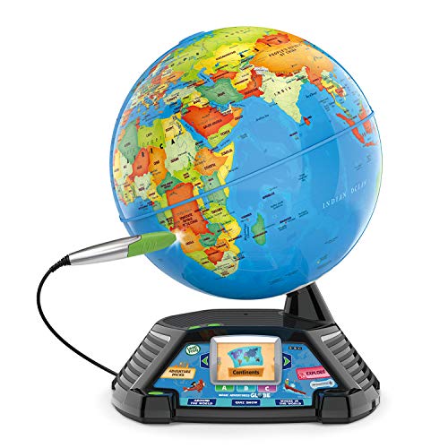
- 2.8" screen with BBC video clips
- Thousands of facts plus quiz games
- Covers countries, capitals, cultures, and habitats
Best For: Kids ages 5+ who enjoy visual, game-based geography learning
Talking Wall Map
BEST LEARNING i-Poster My World

- Touches 92 countries with spoken names
- Over 1,000 facts across 10 modes
- Includes capitals, flags, landmarks, and languages
Best For: Kids ages 5 to 12 in home or classroom settings
U.S. Talking Map

- 1,000 facts on states, capitals, and history
- Two quiz difficulty levels
- Special modes for colonies, Civil War, and elections
Best For: Kids learning U.S. geography, civics, and history
Geography Puzzle Set
Imagimake Mapology USA & World

- 3 puzzles: USA, World, and Europe
- Teaches 65+ countries, capitals, and flags
- Screen-free, hands-on geography learning
Best For: Kids who learn best through puzzles and guided family play
Educational Wall Map
Large World Map for Wall with Flags & Capitals
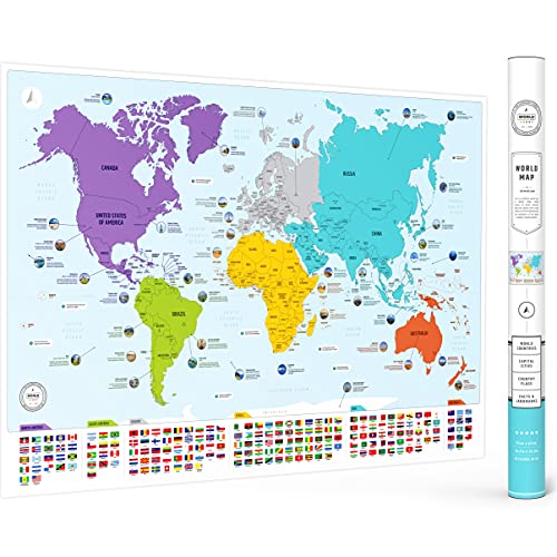
- Countries, flags, and capitals in one poster
- Includes 50 interesting facts
- Large matte 26 x 38 inch format
Best For: Classrooms, homeschool, and room decor
Interactive Sticker Map
World Map Chart with Reusable Stickers

- 100+ reusable stickers and a wall chart
- Five ways to play with timer and spinners
- Built for play-based geography learning
Best For: Kids ages 5+ who learn through hands-on activities
Talking Bilingual Map
Interactive World Map for Kids

- English and Spanish audio learning
- 3,500 facts across 195 countries
- Includes capitals, flags, and more
Best For: Bilingual learners ages 3 to 12 who like audio lessons
USA Geography Puzzle
Learn States, Capitals with Flags
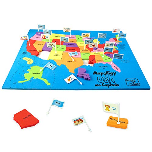
- 50 state-shaped EVA foam pieces
- Capital flags and fun fact stickers
- ASTM-standard sturdy educational build
Best For: hands-on U.S. geography learning and homeschool use
Interactive World Geography Set
Interactive World Map With Talking Pen

- Talking pen plays facts, prompts, and music
- 3,500 facts plus 15 quiz games
- Covers 195 countries, flags, and capitals
Best For: audio-based world geography learning and gift-giving
World Geography Puzzle
Countries, Flags and Capitals Puzzle

- 75 country-shaped EVA foam pieces
- Includes 65 flags and capital stickers
- Adds a Europe map for extra detail
Best For: puzzle-based world geography and homeschool lessons
Interactive Globe – LeapFrog Magic Adventures Globe
If you want interactive maps with countries and capitals that feel more like an experience than a lesson, this LeapFrog globe adds video, quizzes, and talking facts to classic geography play. It goes beyond naming places by showing cultures, animals, habitats, and more through guided activities and BBC video clips.
Best For: Young kids ages 5+ who learn best with hands-on geography games and visual content.
Pros:
- Includes a 2.8″ video screen with over five hours of BBC videos.
- Lets kids hear thousands of facts and play three interactive games.
- Combines a globe, stylus, and quiz play for active learning.
Cons:
- Requires 4 AA batteries, so ongoing use needs fresh replacements.
- Best suited to one child at a time.
- Learning focus is broad geography rather than deep country-by-country reference.
This is a strong pick if you want a multimedia globe that keeps children engaged while reinforcing geography basics in a playful way.
Talking Wall Map – BEST LEARNING i-Poster My World
For shoppers comparing interactive maps with countries and capitals, this wall poster stands out for its touch-based format and large amount of spoken content. Kids can press countries to hear names, facts, capitals, flags, landmarks, languages, and population details without needing an app or pen.
Best For: Ages 5 to 12 who like a wall-mounted geography map with quiz modes and spoken facts.
Pros:
- Recognizes 92 countries by touch.
- Includes over 1,000 spoken facts across 10 quiz-and-learn modes.
- Comes with batteries and offers 5 volume levels for flexible use.
Cons:
- It is a wall chart/poster style product, not a tabletop toy.
- Requires AAA batteries.
- Designed for children, so it is less suited to advanced geography study.
This is a practical choice for families or classrooms that want a durable, easy-to-use talking map with a lot of repeat play value.
U.S. Talking Map – Zanzoon myTouch USA Map Game
If your goal is interactive maps with countries and capitals for U.S.-focused learning, this talking map centers on American geography and history rather than the whole world. It adds quiz play, two difficulty levels, and special modes for the 13 colonies, the Civil War, and electoral votes.
Best For: Kids who want a U.S.-only geography and history map with game-style learning.
Pros:
- Includes 1,000 facts covering states, capitals, geography, and history.
- Offers two difficulty levels for quiz play.
- Has extra modes for the 13 colonies, the Civil War, and electoral votes.
Cons:
- Focuses on the United States, not world countries.
- Uses manual operation rather than automated touch behavior.
- Only supports 2 players.
This is a good fit if you want a more specialized talking map that blends U.S. states-and-capitals practice with history and civics content.
Geography Puzzle Set – Imagimake Mapology USA & World
For families looking for interactive maps with countries and capitals in a screen-free format, this puzzle set teaches geography through matching shapes, flags, and stickers. It combines USA, World, and Europe maps in one box, making it a hands-on option for kids who learn by building.
Best For: Kids ages 5 to 12 who enjoy puzzle-based geography learning and family activity time.
Pros:
- Includes 3 map puzzles: USA, World, and Europe.
- Teaches more than 65 countries along with capitals and flags.
- Uses shaped pieces and sticker sets to make geography more memorable.
Cons:
- It is a puzzle set, so it does not provide spoken or electronic feedback.
- Assembly takes more time than a simple map poster or talking toy.
- Best for guided play rather than solo reference use.
This is a strong screen-free option if you want a geography activity that mixes map recognition, puzzle solving, and parent-child interaction.
Educational Wall Map – Large World Map for Wall with Flags & Capitals
If you want interactive maps with countries and capitals that also double as wall decor, this large world map poster is a simple, visual learning tool. It lays out countries, flags, capitals, and color-coded continents in a format that works well for classrooms, homeschool spaces, bedrooms, or offices.
Best For: Kids and adults who want a colorful, frame-ready geography poster for everyday learning.
Pros:
- Shows countries, flags, and capitals together for straightforward geography study.
- Includes 50 interesting facts to add more learning value.
- Large 26 x 38 inch size with a matte finish for easier display and durability.
- Versatile as classroom, homeschool, or room decor.
Cons:
- Not a scratch map, so it does not offer hands-on activity features.
- Works best as a poster-style reference rather than an electronic or playable map.
Overall, this is a practical choice if you want a colorful educational map that makes country-and-capital learning visible at a glance. It is especially appealing when you want wall art that also serves a real geography purpose.
Interactive Sticker Map – World Map Chart with Reusable Stickers
For families looking for interactive maps with countries and capitals that feel more like a game than a poster, this world map chart adds a lot of hands-on engagement. Kids place reusable stickers, use the timer and spinners, and explore continents, landmarks, animals, and foods while building geography skills.
Best For: Kids ages 5+ who learn best through play-based geography activities.
Pros:
- Includes 100+ reusable stickers plus a world map chart for repeat play.
- Five ways to play help reinforce geography through numbers, timing, continents, atlas-style learning, and directions.
- Comes with a sand timer, two spinners, and an instruction book for guided activities.
- Supports classroom and homeschool use while building memory and spatial understanding.
Cons:
- Requires active participation, so it is not a simple static reference map.
- Best suited to children rather than older users wanting a traditional wall map.
This set stands out if you want geography learning to be interactive and repeatable. It is a strong pick for parents and teachers who want a map-based activity that keeps kids moving, matching, and thinking.
Talking Bilingual Map – Interactive World Map for Kids
If you want interactive maps with countries and capitals that go beyond a printed poster, this bilingual talking world map adds audio-based learning. The included pen lets kids explore countries, capitals, population, language, animals, oceans, and more in English or Spanish, making it a strong option for curious learners.
Best For: Children ages 3 to 12 who benefit from bilingual, audio-led geography learning.
Pros:
- Talks in English and Spanish for bilingual learning support.
- Includes 3,500 fun facts about 195 countries for broad geography coverage.
- Audio pen and recording features add a more interactive experience.
- Covers capitals along with flags, population, language, animals, and oceans.
Cons:
- Needs batteries, so it is less simple than a standard poster map.
- Best for children who will use the audio pen, not for purely decorative display.
This is the most feature-rich option in the group if you want a map that speaks and teaches. It is a good fit for homes that want geography lessons to feel dynamic, bilingual, and highly interactive.
USA Geography Puzzle – Learn States, Capitals with Flags
If you want interactive maps with countries and capitals style learning for the United States, this USA map jigsaw turns geography into a hands-on puzzle. Kids place the 50 state-shaped pieces, add the capital flags, and use the fun fact stickers to build familiarity with locations, capitals, and state trivia.
Best For: Kids who learn best through tactile puzzles, homeschool geography lessons, and families looking for a screen-free U.S. map activity.
Pros:
- Includes 50 state-shaped EVA foam pieces for map-building play.
- Capital stickers and flags help reinforce state capitals visually.
- Fun fact stickers add extra learning for each state.
- Made with sturdy EVA foam and designed to meet ASTM toy standards.
Cons:
- Focused on the USA, so it is not a world geography option.
- Best suited to tabletop play rather than quick, portable quizzes.
This is a practical choice if you want a geography toy that combines puzzle solving with capital memorization. It offers a clear learning path for children who benefit from seeing and handling each state as they learn.
Interactive World Geography Set – Interactive World Map With Talking Pen
For buyers searching for interactive maps with countries and capitals, this world map set goes beyond a printed chart by adding a talking pen and quiz play. Kids can tap countries to hear facts, explore capitals and flags, and use the included music and greeting cards for a more varied learning experience.
Best For: Children ages 5-12 who enjoy audio-based learning, quiz games, and a colorful world geography gift.
Pros:
- Talking pen brings the map to life with facts, prompts, and world music.
- Includes 3,500 facts and 15 quiz games across three difficulty levels.
- Covers 195 countries, along with flags, capitals, and more.
- Roll-up design and protective tube help keep the map in good condition.
Cons:
- Requires active use of the talking pen for the full interactive experience.
- The narrow rolled format may feel less like a traditional wall map display.
This is a strong pick if you want an engaging, audio-driven geography tool that makes world learning feel like a game. It stands out for variety, with facts, quizzes, music, and presentation all bundled together.
World Geography Puzzle – Countries, Flags and Capitals Puzzle
This world puzzle is a good fit if you want interactive maps with countries and capitals in a physical, hands-on format. Children assemble country-shaped foam pieces, add flag stickers, and use the included Europe map to connect countries, borders, flags, and capitals in one learning activity.
Best For: Kids who like jigsaw-style geography puzzles and families building homeschool or classroom map skills.
Pros:
- Includes 75 country-shaped foam pieces for spatial learning.
- Comes with 65 world flags and capital stickers.
- Extra Europe map adds a more detailed regional learning layer.
- Made with 8 mm EVA foam and described as ASTM-standard safe.
Cons:
- Assembly is more involved than a simple flat map.
- Best for children who enjoy puzzle-based learning rather than quick reference use.
Overall, this is a well-rounded geography puzzle for kids who like learning through building and sorting. It offers more depth than a basic map poster, especially for children who benefit from country pieces and visual flag matching.
How We Picked These Interactive Maps with Countries and Capitals
We looked for products that make geography learning active, not passive. That means clear country-and-capital coverage, strong interactivity, and formats that suit different ages and learning styles. We also favored maps with good educational value, durable construction, and features that keep kids engaged longer than a single session.
Quick Comparison
Think of these options in three broad groups: talking world maps for guided learning, puzzle-style maps for hands-on retention, and wall charts or posters for easy reference. If you want a screen-free study tool, puzzles and charts are usually the best fit. If you want quizzes, audio prompts, or bilingual support, talking maps are often the better choice.
Key Buying Factors for Interactive Maps with Countries and Capitals
Age and Skill Level
Match the map to the learner. Younger children usually do better with simple quizzes, color cues, and big visual labels. Older kids may benefit more from state-level detail, harder question modes, or broader world geography coverage.
Learning Format
Choose the format that fits how your child learns best. Puzzles build memory through placement and repetition. Talking maps add spoken prompts and feedback. Posters and wall maps work well as daily reference tools, especially for review and reinforcement.
Depth of Geography Content
Some products focus on country names and capitals, while others add flags, continents, landmarks, or states. If your goal is broad geography knowledge, look for layered content rather than a map that only lists labels.
Durability and Usability
For regular use, check material quality, piece fit, and how easy the map is to handle or mount. Reusable stickers, sturdy puzzle pieces, and clear print can make a big difference in long-term value.
Who Should Buy Which Interactive Maps with Countries and Capitals?
If you want the most engaging experience for young learners, choose a talking or quiz-based map. If your child prefers hands-on activities, a puzzle-style option is usually the strongest choice. For classrooms, homeschool spaces, or bedrooms, a large wall map or poster can be the most practical companion because it keeps geography visible every day.
Overall, the best Interactive Maps with Countries and Capitals are the ones that match the learner’s age, attention span, and preferred way of studying. Pick the format that will get used consistently, and the geography knowledge is much more likely to stick.