Looking for a world map that does more than fill wall space? The right pick can make geography easier to learn, quicker to review, and more engaging for kids and adults alike.
This roundup of the best world maps with countries and capitals focuses on clarity, durability, and learning value so you can choose a map or learning set that fits your space and goals.
Best 10 World Maps with Countries and Capitals Picks for 2026
Educational Wall Map
Large World Map for Wall with Flags & Capitals
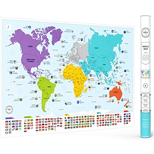
- Shows countries, flags, capitals, and continents
- Includes 50 interesting facts
- 26 x 38 inch matte poster
Best For: Kids, homeschool, and classroom geography decor
Oversized Classroom Map
Giant World Map 46 x 80 Laminated

- Huge 46 x 80 inch single-sheet map
- Laminated and write-on with dry-erase pen
- Updated 2026 political map with shaded relief
Best For: Large classrooms and study walls
Hands-On Geography Puzzle

- Three puzzles: USA, World, and Europe
- Includes capitals, flags, and fun facts
- Hands-on learning for ages 5-12
Best For: Homeschooling and screen-free kids' geography play
Classic Laminated Map
24x36 World Classic Premier Wall Map

- Laminated UV coating with dry-erase support
- 3D shaded relief for added detail
- 24 x 36 inch current political map
Best For: Home, business, or educational use
Geography Study Set
World Geography Flash Cards for Countries, Flags & Capitals

- 290 cards for countries, U.S. states, and maps
- Covers flags, capitals, currencies, and facts
- Portable box makes review easy anywhere
Best For: Teen and adult learners needing a portable geography study aid
Geography Card Game
The World Game for Countries, Flags & Capitals
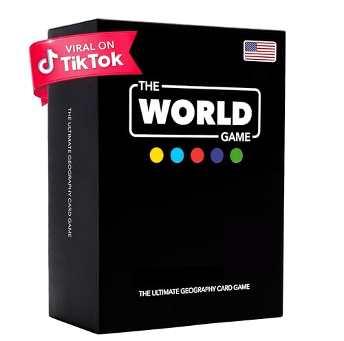
- Includes all 194 countries and a world map
- Covers flags, capitals, and country location
- Playable as a game, flash cards, or trivia
Best For: Families and learners who prefer interactive geography practice
Reference Wall Map
National Geographic World Map with Flags & Facts

- Shows countries, cities, boundaries, and features
- Adds capital city, population, GDP, and flag data
- Waterproof, tear-resistant paper for durability
Best For: Shoppers wanting a durable, authoritative world reference map
GeoPuzzle Family Learning Pick
GeoPuzzle World Jigsaw Puzzles, 68 Pc Map Puzzle for Kids

- 68-piece country-shaped world map puzzle
- Encourages learning countries, states, capitals, and provinces
- Large format supports family geography play
Best For: Families and kids ages 6+ who learn best by doing
Flashcard Study Pick
World Flags Flashcards, 245+ Country & Map Geography Game

- 245 cards include country name, capital, continent, language, and flag
- Comes with a world map and game instructions
- Durable laminated cardstock for repeated study
Best For: Teens, adults, and classrooms needing a portable geography reference
Capital Sticker Puzzle Pick
Imagimake Mapology World Map Puzzle

- Includes country pieces, flag stickers, and capital stickers
- Three foam frames plus a Europe map add learning detail
- EVA foam build supports safe, hands-on geography practice
Best For: Kids 5-12 who learn geography through puzzles and visual assembly
Educational Wall Map – Large World Map for Wall with Flags & Capitals
If you want world maps with countries and capitals that are both decorative and genuinely useful, this colorful wall poster is a strong pick. It shows all countries, flags, capitals, and color-coded continents, plus 50 interesting facts, making it a simple way to turn a wall into a geography learning space.
Best For: Kids, homeschool rooms, classrooms, and adults who want an easy-to-read educational wall map.
Pros:
- Includes all countries, flags, capitals, and color-coded continents for fast learning.
- Adds 50 interesting facts, which gives it more educational value than a basic map poster.
- Large 26 x 38 inch size with vibrant colors and a matte finish.
- Works well as wall decor for classrooms, bedrooms, offices, or homeschool spaces.
Cons:
- It is not a scratch map, so it is purely a display-and-learn poster.
- Paper poster format means it may need framing for the most polished look.
This is a practical choice if you want a bright, easy-to-use world map that teaches countries and capitals while still looking good on the wall. It balances visual appeal with clear geography content, which makes it especially useful for learning-focused spaces.
Oversized Classroom Map – Giant World Map 46 x 80 Laminated
For shoppers comparing world maps with countries and capitals, this giant laminated poster stands out for sheer size and classroom-friendly durability. It is an updated 2026 political world map with colored countries, clear towns and cities, and hill and sea shading, so it works well when readability matters.
Best For: Classrooms, study walls, and anyone who wants a very large write-on world map.
Pros:
- Massive 46 x 80 inch single-sheet format makes it highly visible on a wall.
- Updated 2026 political map with colored countries, towns, cities, and shaded terrain.
- Laminated surface can be written on with a whiteboard pen and wiped clean.
- Rolled in a tube for crease-less delivery.
Cons:
- Its extra-large size may be too big for smaller rooms or tight wall spaces.
- Political map focus means it is more functional than decorative.
This is a strong choice if you need a high-impact classroom or study map that can handle repeated use. The laminated finish and write-on feature add practical value, while the large format makes country locations easier to reference at a glance.
Hands-On Geography Puzzle – USA & World Map Puzzle Set
If you want world maps with countries and capitals in a more interactive format, this puzzle set turns geography into a hands-on activity. It includes USA, World, and Europe map puzzles, plus flag stickers and fun facts, so kids learn by placing pieces instead of just looking at a poster.
Best For: Kids ages 5-12, homeschooling, and families who want a screen-free geography activity.
Pros:
- Includes three map puzzles in one box: USA, World, and Europe.
- Country and state shaped pieces help children learn shapes, sizes, and locations.
- Comes with capitals, flag stickers, and fun facts for added learning.
- Designed for family bonding and homeschooling activities.
Cons:
- It is a puzzle set, not a wall map poster.
- Best suited to children rather than adults seeking wall decor.
This is a smart pick if you want geography learning to feel like play. The puzzle format is especially useful for helping kids remember countries, capitals, and neighbors through repeated hands-on practice.
Classic Laminated Map – 24×36 World Classic Premier Wall Map
For buyers looking at world maps with countries and capitals, this laminated classic is a straightforward, practical option. It is a current political and topographic world map with 3D shaded relief, and the coated finish makes it a useful fit for home, business, or educational settings.
Best For: Home offices, classrooms, and anyone who wants a durable mid-size world wall map.
Pros:
- Laminated UV coating adds durability and supports dry-erase use.
- 3D shaded relief gives the map more depth and visual detail.
- 24 x 36 inch size is easy to place in smaller spaces.
- Completely current political world map for general reference.
Cons:
- Smaller than oversized classroom maps.
- Focuses on a practical look rather than decorative color.
This map is a solid middle-ground choice if you want something current, durable, and easy to display. It is especially appealing for buyers who want a clean reference map that can handle regular use without taking over the room.
Geography Study Set – World Geography Flash Cards for Countries, Flags & Capitals
If you want world maps with countries and capitals in a compact study format, this flash card set gives you a lot of coverage in a small space. It includes countries, flags, political maps, capitals, currencies, populations, and other geography facts, making it a practical choice for structured review and memorization.
Best For: Teen and adult learners who want a portable geography study aid for classroom review, homeschooling, or test prep.
Pros:
- 290 flash cards cover 240 world countries plus 50 U.S. states
- Includes flags, maps, capitals, currencies, populations, and key facts
- Portable standard-size cards come with a storage box
- Useful for high school, college, teachers, and self-study
Cons:
- Designed for teen and adult learners, not children 12 or younger
- Focuses on study and recall rather than a full wall-map reference
- Best suited to independent learning or guided review sessions
This is a strong option if your goal is to learn countries and capitals through repetition and quick drills. It works especially well when you want a study tool that is easy to store, carry, and use in short sessions.
Geography Card Game – The World Game for Countries, Flags & Capitals
For a more interactive take on world maps with countries and capitals, this geography card game blends learning with competition. Players use country location, flags, and capital cities while a included world map helps keep the geography visual and easy to follow.
Best For: Families, kids, and adults who want a fun geography game that reinforces country locations and capitals.
Pros:
- Includes all 194 countries and a world map
- Covers flags, capitals, and country location
- Works as a game, flash card set, or trivia-style activity
- Portable format for travel, road trips, or home play
Cons:
- Requires 2 to 5 players, so it is not a solo-only option
- More game-focused than a dedicated reference map
- Best if you enjoy learning through play and repeated rounds
This is a smart pick if you want geography practice to feel less like studying and more like game night. It gives you a practical way to reinforce capitals and country recognition while keeping the experience engaging.
Reference Wall Map – National Geographic World Map with Flags & Facts
If you want world maps with countries and capitals in a durable reference format, this National Geographic folded map is built for display and travel use. It combines clearly defined international boundaries, city names, and national facts with flags, area, population, and capital city information.
Best For: Shoppers who want an authoritative, durable world reference map for study, travel, or home use.
Pros:
- Shows countries, cities, boundaries, and physical features clearly
- Includes each country’s area, population, capital city, GDP per capita, and flag
- Printed on waterproof, tear-resistant synthetic paper
- Folded format is designed for travel and repeated handling
Cons:
- Folded map format is less interactive than cards or a game
- Best for reference use rather than active memorization drills
- Needs unfolding for full-world viewing
This is the strongest choice if your priority is an accurate, easy-to-read world reference map rather than a study activity. It pairs well with classroom work, trip planning, or any setting where durable geography details matter.
GeoPuzzle Family Learning Pick – GeoPuzzle World Jigsaw Puzzles, 68 Pc Map Puzzle for Kids
If you want a hands-on way to introduce world maps with countries and capitals, this GeoPuzzle set turns geography into a family activity. The country-shaped pieces and bright colors make it easier for kids to explore how countries fit together while building map awareness and fine motor skills.
Best For: Families, kids ages 6+, and shared geography learning at home or in school.
Pros:
- 68-piece map puzzle with country-shaped pieces for interactive learning
- Designed to encourage exploration of countries, states, capitals, and provinces
- Large 26 in x 12.5 in format gives kids plenty of space to work
- Supports teamwork, cognitive growth, and fine motor skills
Cons:
- Focused more on puzzle-based learning than reference-style study
- May be best suited to younger learners and family use rather than advanced geography review
Overall, this is a practical pick if you want a playful, tactile introduction to geography. It stands out for making country discovery feel like a group activity while still reinforcing map skills and capital awareness.
Flashcard Study Pick – World Flags Flashcards, 245+ Country & Map Geography Game
For shoppers looking for world maps with countries and capitals in a compact study format, these flashcards work more like a fast reference and quiz tool than a traditional puzzle. Each card includes the country or territory name, capital, continent, language(s), flag, and a local greeting, making it easy to build geography knowledge in short sessions.
Best For: Teens, adults, classrooms, and homeschoolers who want a portable geography study set.
Pros:
- 245 country/territory cards with capitals, continents, languages, and flags
- Includes a world map plus an instruction sheet for games and study
- Designed for quizzes, flag matching, and continent-hunt style learning
- Thick, tear-resistant, waterproof laminated cardstock for repeated use
Cons:
- Not a hands-on map puzzle, so it may be less engaging for tactile learners
- Card format is compact, which may feel small for some users
This set is a strong choice if you want quick, versatile geography practice rather than a buildable map. It works well as a study aid, game deck, or classroom reference for learning country facts and capitals.
Capital Sticker Puzzle Pick – Imagimake Mapology World Map Puzzle
This world map option is built for families who want world maps with countries and capitals presented through an interactive puzzle. It combines country-shaped foam pieces, flag stickers, and capital stickers to help kids learn borders, flags, and capital placement while they assemble the map.
Best For: Kids ages 5 to 12, homeschoolers, and parents looking for an educational foam map puzzle.
Pros:
- Includes 75 country-shaped puzzle pieces plus 65 flags and capital stickers
- Comes with three foam puzzle frames and a Europe map for added geography detail
- Supports problem-solving, concentration, spatial awareness, and fine motor skills
- Made from 8 mm EVA foam and designed to meet ASTM toy standards
Cons:
- Requires sticker application, so setup takes more time than a simple puzzle
- Learning is centered on assembly, not on built-in text-heavy study material
Overall, this is a well-rounded educational puzzle for visual learners who benefit from building the map themselves. The capital stickers and flag pieces add extra learning layers without losing the hands-on appeal.
How We Picked the Best World Maps with Countries and Capitals
We looked for products that make geography simple to read and useful in real-world settings. Priority went to clear country labeling, visible capital placement, strong map layout, and formats that suit different ages, from wall posters to puzzles and flash cards. Durability, educational value, and ease of use also mattered.
Quick Comparison
Wall maps are best for everyday reference and room decor, while puzzles and games work better for hands-on learning. Flash cards are ideal for memorization and quiz-style practice. Folded reference maps can be the most portable option if you want a study aid you can store easily.
Key Buying Factors for World Maps with Countries and Capitals
Readability
Choose a map with clear font sizes, strong contrast, and uncluttered borders. If the map is for younger learners, larger labels and simplified design can make a big difference.
Accuracy and Detail
For World Maps with Countries and Capitals, check that country boundaries, capital markers, flags, and legends are easy to interpret. More detail is not always better if it makes the map harder to read.
Format and Size
Large wall posters are best for classrooms, kitchens, and study areas. Smaller laminated maps and fold-out references suit desks, backpacks, and travel. Puzzle and game formats are better when learning needs to feel interactive.
Durability
Laminated finishes, sturdy card stock, and thick puzzle pieces help maps hold up to repeated use. If children will handle it often, durability should be a top priority.
Who Should Buy Which World Maps with Countries and Capitals?
Parents and teachers who want a visual reference should choose a wall map. Families looking for a more engaging activity should consider puzzles or card games. Students preparing for tests may get the most value from flash cards or a compact reference map. If you want both decoration and instruction, a large poster with countries and capitals is usually the most versatile option.
For most buyers, the best choice comes down to how the map will be used every day. If you want quick reference, choose display. If you want memorization, choose cards. If you want hands-on learning, choose a puzzle or game.